Cogolin geodata
Cogolin (Provence-Alpes-Côte d'Azur) is a populated place; located in France in Europe/Paris (GMT+2) time zone. With population of 9,838 people, there are 967 cities with bigger population in this country. Compared to other cities in France, 96.5% of cities are located further ↑North; 91.9% of cities are located further ←West and 88.6% of cities have higher elevation than Cogolin. Note1
Administrative division(s):
- Level 1: Provence-Alpes-Côte d'Azur
- Level 2: Var
- Level 3: Arrondissement de Draguignan
- Level 4: Cogolin


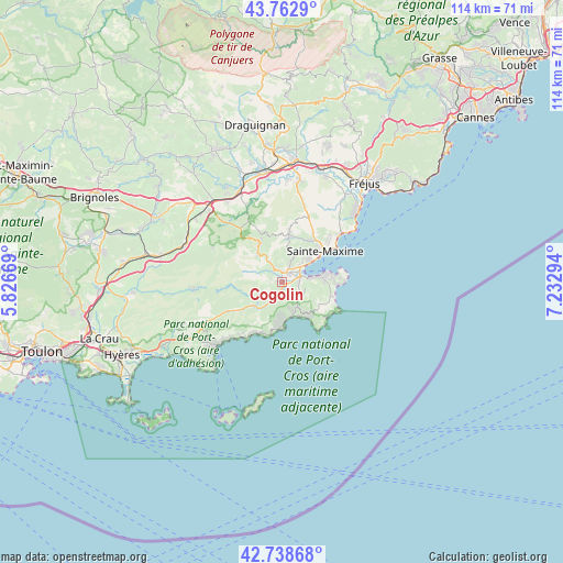
Cogolin GPS coordinates[2]
43° 15' 10.584" North, 6° 31' 47.316" East
| Map corner | latitude | longitude |
|---|---|---|
| Upper-left | 43.7629°, | 5.82669° |
| Center: | 43.25294°, | 6.52981° |
| Lower-right: | 42.73868°, | 7.23294° |
| Map W x H: | 113.9×113.9 km | = 70.8×70.8mi |
| max Lat: | 51.07786° ⇑96.5% North |
| Cogolin: | 43.25294° |
| min Lat: | ⇓3.5% South 41.3874° |
| min Long | Cogolin | max Long |
| -5.08615° | 6.52981° | 9.52242° |
| W 91.9%⇐ | ⇒8.1% E |
Elevation
Elevation of Cogolin is 33 m = 108 ft, and this is 160.7 m = 527 ft below average elevation for this country.
| Max E: |
2333 m = 7654 ft | 88.6% |
| Avg. | 193.7 m = 635 ft | |
| Cogolin | 33 m = 108 ft | |
Min E: |
-1 m = -3 ft | 11.4% |
See also: France elevation on elevation.city.
Geographical zone
Cogolin is located in North temperate zone (between Tropic of Cancer and the Arctic Circle). Distance of this Northern Tropic circle is 2203.4 km =1369.1 mi to South.| Distance of | km | miles | from Cogolin |
|---|---|---|---|
| North Pole | 5197.8 | 3229.8 | to North |
| Arctic Circle | 2591.9 | 1610.5 | to North |
| Tropic Cancer | 2203.4 | 1369.1 | to South |
| Equator | 4809.3 | 2988.4 | to South |


Nearby cities:
15 places around Cogolin: (largest is in red/bold)
• Bormes-les-Mimosas
18.9 km =11.7 mi,  233°
233°
• Cavalaire-sur-Mer
8.9 km =5.5 mi,  180°
180°
• Collobrières
18 km =11.2 mi,  264°
264°
• Gassin
5.2 km =3.2 mi,  120°
120°
• Gonfaron
20.9 km =13 mi,  291°
291°
• Grimaud
2.4 km =1.5 mi,  343°
343°
• La Croix-Valmer
5.9 km =3.7 mi,  148°
148°
• La Garde-Freinet
8.6 km =5.3 mi,  325°
325°
• La Môle
7.2 km =4.5 mi,  224°
224°
• Le Lavandou
18.5 km =11.5 mi, 225°
• Le Plan-de-la-Tour
9.1 km =5.7 mi,  10°
10°
• Les Mayons
15.4 km =9.6 mi,  295°
295°
• Ramatuelle
7.8 km =4.8 mi, 121°
• Saint-Tropez
9.1 km =5.7 mi,  79°
79°
• Sainte-Maxime
10.8 km =6.7 mi,  54°
54°
Sources, notices
• [Note1] Compared only with cities in France existing in our database
• [Src1] Map data: © OpenStreetMap contributors (CC-BY-SA)
• [Src2] Other city data from geonames.org with taken over terms of usage.
• [Src3] Geographical zone / Annual Mean Temperature by Robert A. Rohde @ Wikipedia
