Rémalard geodata
Rémalard (Normandy) is a populated place; located in France in Europe/Paris (GMT+2) time zone. With population of 1,268 people, there are 7192 cities with bigger population in this country. Compared to other cities in France, 66.8% of cities are located further ↓South; 70.8% of cities are located further →East and 51.9% of cities have lower elevation than Rémalard. Note1
Administrative division(s):
- Level 1: Normandy
- Level 2: Département de l'Orne
- Level 3: Arrondissement de Mortagne-au-Perche
- Level 4: Rémalard en Perche


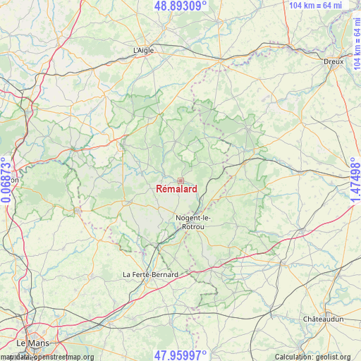
Rémalard GPS coordinates[2]
48° 25' 43.212" North, 0° 46' 18.66" East
| Map corner | latitude | longitude |
|---|---|---|
| Upper-left | 48.89309°, | 0.06873° |
| Center: | 48.42867°, | 0.77185° |
| Lower-right: | 47.95997°, | 1.47498° |
| Map W x H: | 103.8×103.8 km | = 64.5×64.5mi |
| max Lat: | 51.07786° ⇑33.2% North |
| Rémalard: | 48.42867° |
| min Lat: | ⇓66.8% South 41.3874° |
| min Long | Rémalard | max Long |
| -5.08615° | 0.77185° | 9.52242° |
| W 29.2%⇐ | ⇒70.8% E |
Elevation
Elevation of Rémalard is 139 m = 456 ft, and this is 54.7 m = 179 ft below average elevation for this country.
| Max E: |
2333 m = 7654 ft | 48.1% |
| Avg. | 193.7 m = 635 ft | |
| Rémalard | 139 m = 456 ft | |
Min E: |
-1 m = -3 ft | 51.9% |
See also: France elevation on elevation.city.
Geographical zone
Rémalard is located in North temperate zone (between Tropic of Cancer and the Arctic Circle). Distance of this North polar circle is 2016.4 km =1252.9 mi to North.| Distance of | km | miles | from Rémalard |
|---|---|---|---|
| North Pole | 4622.3 | 2872.2 | to North |
| Arctic Circle | 2016.4 | 1252.9 | to North |
| Tropic Cancer | 2778.8 | 1726.7 | to South |
| Equator | 5384.8 | 3346 | to South |


Nearby cities:
15 places around Rémalard: (largest is in red/bold)
• Bellême
16.1 km =10 mi,  247°
247°
• Bretoncelles
8.6 km =5.3 mi,  88°
88°
• Brunelles
14.7 km =9.1 mi,  142°
142°
• Condé-sur-Huisne
7.9 km =4.9 mi,  132°
132°
• La Chapelle-Montligeon
10.4 km =6.5 mi,  304°
304°
• La Rouge
16.4 km =10.2 mi,  196°
196°
• Longny-au-Perche
11.3 km =7 mi,  352°
352°
• Margon
11.3 km =7 mi,  155°
155°
• Mauves-sur-Huisne
11.4 km =7.1 mi,  282°
282°
• Moutiers-au-Perche
7.7 km =4.8 mi,  45°
45°
• Neuilly-sur-Eure
15.9 km =9.9 mi,  37°
37°
• Nocé
8.7 km =5.4 mi,  230°
230°
• Nogent-le-Rotrou
12.5 km =7.8 mi, 162°
• Préaux-du-Perche
11.4 km =7.1 mi, 201°
• Saint-Hilaire-sur-Erre
13.2 km =8.2 mi,  190°
190°
Sources, notices
• [Note1] Compared only with cities in France existing in our database
• [Src1] Map data: © OpenStreetMap contributors (CC-BY-SA)
• [Src2] Other city data from geonames.org with taken over terms of usage.
• [Src3] Geographical zone / Annual Mean Temperature by Robert A. Rohde @ Wikipedia
