Meyrueis geodata
Meyrueis (Occitanie) is a populated place; located in France in Europe/Paris (GMT+2) time zone. With population of 1,084 people, there are 8234 cities with bigger population in this country. Compared to other cities in France, 85.7% of cities are located further ↑North; 63.6% of cities are located further ←West and 96.8% of cities have lower elevation than Meyrueis. Note1
Administrative division(s):
- Level 1: Occitanie
- Level 2: Département de la Lozère
- Level 3: Arrondissement de Florac
- Level 4: Meyrueis


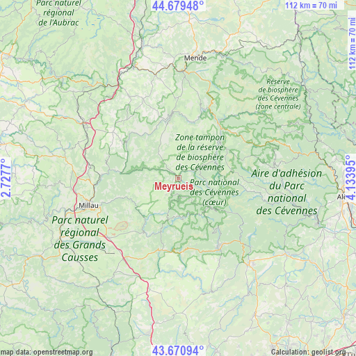
Meyrueis GPS coordinates[2]
44° 10' 38.532" North, 3° 25' 50.988" East
| Map corner | latitude | longitude |
|---|---|---|
| Upper-left | 44.67948°, | 2.7277° |
| Center: | 44.17737°, | 3.43083° |
| Lower-right: | 43.67094°, | 4.13395° |
| Map W x H: | 112.1×112.1 km | = 69.7×69.7mi |
| max Lat: | 51.07786° ⇑85.7% North |
| Meyrueis: | 44.17737° |
| min Lat: | ⇓14.3% South 41.3874° |
| min Long | Meyrueis | max Long |
| -5.08615° | 3.43083° | 9.52242° |
| W 63.6%⇐ | ⇒36.4% E |
Elevation
Elevation of Meyrueis is 705 m = 2313 ft, and this is 511.3 m = 1677 ft above average elevation for this country.
| Max E: |
2333 m = 7654 ft | 3.2% |
| Meyrueis | 705 m 2313 ft | |
| Avg. | 193.7 m = 635 ft | |
Min E: |
-1 m = -3 ft | 96.8% |
See also: France elevation on elevation.city.
Geographical zone
Meyrueis is located in North temperate zone (between Tropic of Cancer and the Arctic Circle). Distance of this Northern Tropic circle is 2306.1 km =1432.9 mi to South.| Distance of | km | miles | from Meyrueis |
|---|---|---|---|
| North Pole | 5095 | 3165.9 | to North |
| Arctic Circle | 2489.1 | 1546.7 | to North |
| Tropic Cancer | 2306.1 | 1432.9 | to South |
| Equator | 4912.1 | 3052.2 | to South |


Nearby cities:
15 places around Meyrueis: (largest is in red/bold)
• Aguessac
26.6 km =16.5 mi,  264°
264°
• Avèze
26.7 km =16.6 mi,  149°
149°
• Compeyre
26.2 km =16.3 mi,  266°
266°
• Florac
21 km =13 mi,  37°
37°
• Ispagnac
23.1 km =14.4 mi,  21°
21°
• La Cavalerie
28.7 km =17.8 mi,  229°
229°
• Le Vigan
24.9 km =15.5 mi, 145°
• Millau
29.5 km =18.3 mi,  252°
252°
• Molières-Cavaillac
25.3 km =15.7 mi, 152°
• Nant
20.1 km =12.5 mi,  210°
210°
• Rivière-sur-Tarn
23.9 km =14.9 mi, 273°
• Saint-André-de-Majencoules
25.6 km =15.9 mi,  130°
130°
• Saint-Jean-du-Bruel
18.2 km =11.3 mi,  197°
197°
• Sainte-Enimie
21.1 km =13.1 mi,  356°
356°
• Valleraugue
19.9 km =12.4 mi,  122°
122°
Sources, notices
• [Note1] Compared only with cities in France existing in our database
• [Src1] Map data: © OpenStreetMap contributors (CC-BY-SA)
• [Src2] Other city data from geonames.org with taken over terms of usage.
• [Src3] Geographical zone / Annual Mean Temperature by Robert A. Rohde @ Wikipedia
