Prudhomat geodata
Prudhomat (Occitanie) is a populated place; located in France in Europe/Paris (GMT+2) time zone. With population of 709 people, there are 11666 cities with bigger population in this country. Compared to other cities in France, 80.5% of cities are located further ↑North; 59.1% of cities are located further →East and 68% of cities have lower elevation than Prudhomat. Note1
Administrative division(s):
- Level 1: Occitanie
- Level 2: Lot
- Level 3: Arrondissement de Figeac
- Level 4: Prudhomat


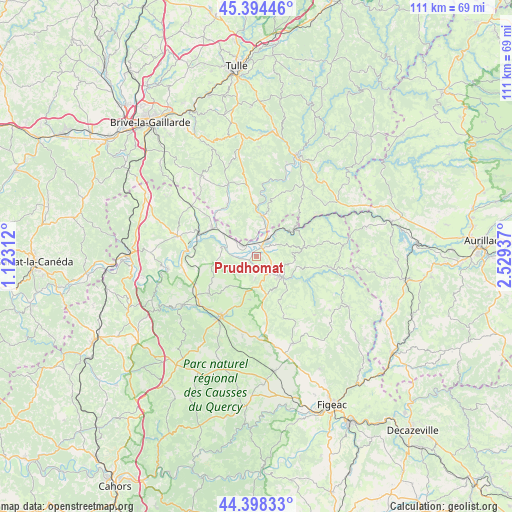
Prudhomat GPS coordinates[2]
44° 53' 54.78" North, 1° 49' 34.464" East
| Map corner | latitude | longitude |
|---|---|---|
| Upper-left | 45.39446°, | 1.12312° |
| Center: | 44.89855°, | 1.82624° |
| Lower-right: | 44.39833°, | 2.52937° |
| Map W x H: | 110.8×110.8 km | = 68.8×68.8mi |
| max Lat: | 51.07786° ⇑80.5% North |
| Prudhomat: | 44.89855° |
| min Lat: | ⇓19.5% South 41.3874° |
| min Long | Prudhomat | max Long |
| -5.08615° | 1.82624° | 9.52242° |
| W 40.9%⇐ | ⇒59.1% E |
Elevation
Elevation of Prudhomat is 209 m = 686 ft, and this is 15.3 m = 50 ft above average elevation for this country.
| Max E: |
2333 m = 7654 ft | 32% |
| Prudhomat | 209 m 686 ft | |
| Avg. | 193.7 m = 635 ft | |
Min E: |
-1 m = -3 ft | 68% |
See also: France elevation on elevation.city.
Geographical zone
Prudhomat is located in North temperate zone (between Tropic of Cancer and the Arctic Circle). Distance of this Northern Tropic circle is 2386.3 km =1482.8 mi to South.| Distance of | km | miles | from Prudhomat |
|---|---|---|---|
| North Pole | 5014.8 | 3116.1 | to North |
| Arctic Circle | 2408.9 | 1496.8 | to North |
| Tropic Cancer | 2386.3 | 1482.8 | to South |
| Equator | 4992.3 | 3102.1 | to South |


Nearby cities:
15 places around Prudhomat: (largest is in red/bold)
• Altillac
9 km =5.6 mi,  11°
11°
• Alvignac
13 km =8.1 mi,  232°
232°
• Aynac
12.8 km =8 mi,  170°
170°
• Beaulieu-sur-Dordogne
8.9 km =5.5 mi, 6°
• Biars-sur-Cère
3.8 km =2.4 mi,  35°
35°
• Bretenoux
2.1 km =1.3 mi,  31°
31°
• Bétaille
8.9 km =5.5 mi,  304°
304°
• Gramat
15.6 km =9.7 mi,  212°
212°
• Leyme
13.7 km =8.5 mi,  155°
155°
• Martel
17.7 km =11 mi,  283°
283°
• Puybrun
3.8 km =2.4 mi,  306°
306°
• Saint-Céré
7.1 km =4.4 mi,  130°
130°
• Saint-Laurent-les-Tours
6 km =3.7 mi,  113°
113°
• Sousceyrac
16.7 km =10.4 mi,  99°
99°
• Vayrac
11.4 km =7.1 mi, 302°
Sources, notices
• [Note1] Compared only with cities in France existing in our database
• [Src1] Map data: © OpenStreetMap contributors (CC-BY-SA)
• [Src2] Other city data from geonames.org with taken over terms of usage.
• [Src3] Geographical zone / Annual Mean Temperature by Robert A. Rohde @ Wikipedia
