Lannepax geodata
Lannepax (Occitanie) is a populated place; located in France in Europe/Paris (GMT+2) time zone. With population of 559 people, there are 14019 cities with bigger population in this country. Compared to other cities in France, 89.1% of cities are located further ↑North; 76% of cities are located further →East and 63.1% of cities have lower elevation than Lannepax. Note1
Administrative division(s):
- Level 1: Occitanie
- Level 2: Gers
- Level 3: Arrondissement de Condom
- Level 4: Lannepax


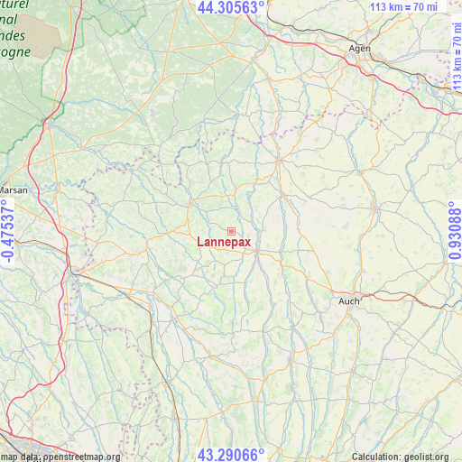
Lannepax GPS coordinates[2]
43° 48' 1.08" North, 0° 13' 39.936" East
| Map corner | latitude | longitude |
|---|---|---|
| Upper-left | 44.30563°, | -0.47537° |
| Center: | 43.8003°, | 0.22776° |
| Lower-right: | 43.29066°, | 0.93088° |
| Map W x H: | 112.9×112.9 km | = 70.2×70.2mi |
| max Lat: | 51.07786° ⇑89.1% North |
| Lannepax: | 43.8003° |
| min Lat: | ⇓10.9% South 41.3874° |
| min Long | Lannepax | max Long |
| -5.08615° | 0.22776° | 9.52242° |
| W 24%⇐ | ⇒76% E |
Elevation
Elevation of Lannepax is 185 m = 607 ft, and this is 8.7 m = 29 ft below average elevation for this country.
| Max E: |
2333 m = 7654 ft | 36.9% |
| Avg. | 193.7 m = 635 ft | |
| Lannepax | 185 m = 607 ft | |
Min E: |
-1 m = -3 ft | 63.1% |
See also: France elevation on elevation.city.
Geographical zone
Lannepax is located in North temperate zone (between Tropic of Cancer and the Arctic Circle). Distance of this Northern Tropic circle is 2264.2 km =1406.9 mi to South.| Distance of | km | miles | from Lannepax |
|---|---|---|---|
| North Pole | 5136.9 | 3191.9 | to North |
| Arctic Circle | 2531 | 1572.7 | to North |
| Tropic Cancer | 2264.2 | 1406.9 | to South |
| Equator | 4870.1 | 3026.1 | to South |


Nearby cities:
15 places around Lannepax: (largest is in red/bold)
• Aignan
16.2 km =10.1 mi,  225°
225°
• Castéra-Verduzan
16.3 km =10.1 mi,  87°
87°
• Caussens
22.4 km =13.9 mi,  44°
44°
• Condom
21 km =13 mi,  33°
33°
• Eauze
12.1 km =7.5 mi,  303°
303°
• Gondrin
9.4 km =5.8 mi,  4°
4°
• Jegun
19.5 km =12.1 mi,  101°
101°
• Manciet
14.8 km =9.2 mi,  269°
269°
• Montréal
16.8 km =10.4 mi,  353°
353°
• Nogaro
21.4 km =13.3 mi,  257°
257°
• Ordan-Larroque
22.5 km =14 mi,  124°
124°
• Parleboscq
23.5 km =14.6 mi,  309°
309°
• Saint-Puy
20.7 km =12.9 mi,  65°
65°
• Valence-sur-Baïse
15.3 km =9.5 mi,  53°
53°
• Vic-Fezensac
7.6 km =4.7 mi,  114°
114°
Sources, notices
• [Note1] Compared only with cities in France existing in our database
• [Src1] Map data: © OpenStreetMap contributors (CC-BY-SA)
• [Src2] Other city data from geonames.org with taken over terms of usage.
• [Src3] Geographical zone / Annual Mean Temperature by Robert A. Rohde @ Wikipedia
