Port-Saint-Louis-du-Rhône geodata
Port-Saint-Louis-du-Rhône (Provence-Alpes-Côte d'Azur) is a populated place; located in France in Europe/Paris (GMT+2) time zone. With population of 8,503 people, there are 1140 cities with bigger population in this country. Compared to other cities in France, 94.4% of cities are located further ↑North; 75.5% of cities are located further ←West and 99.9% of cities have higher elevation than Port-Saint-Louis-du-Rhône. Note1
Administrative division(s):
- Level 1: Provence-Alpes-Côte d'Azur
- Level 2: Département des Bouches-du-Rhône
- Level 3: Arrondissement d'Istres
- Level 4: Port-Saint-Louis-du-Rhône
Current local time in Port-Saint-Louis-du-Rhône:
12:33 PM, MondayDifference from your time zone: hours


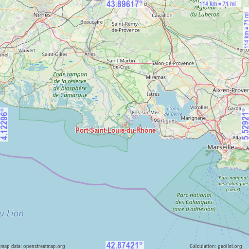
Port-Saint-Louis-du-Rhône GPS coordinates[2]
43° 23' 14.424" North, 4° 49' 33.924" East
| Map corner | latitude | longitude |
|---|---|---|
| Upper-left | 43.89617°, | 4.12296° |
| Center: | 43.38734°, | 4.82609° |
| Lower-right: | 42.87421°, | 5.52921° |
| Map W x H: | 113.6×113.6 km | = 70.6×70.6mi |
| max Lat: | 51.07786° ⇑94.4% North |
| Port-Saint-Louis-du-Rhône: | 43.38734° |
| min Lat: | ⇓5.6% South 41.3874° |
| min Long | Port-Saint-Loui | max Long |
| -5.08615° | 4.82609° | 9.52242° |
| W 75.5%⇐ | ⇒24.5% E |
Elevation
Elevation of Port-Saint-Louis-du-Rhône is 2 m = 7 ft, and this is 191.7 m = 629 ft below average elevation for this country.
| Max E: |
2333 m = 7654 ft | 99.9% |
| Avg. | 193.7 m = 635 ft | |
| Port-Saint-Louis-du-Rhône | 2 m = 7 ft | |
Min E: |
-1 m = -3 ft | 0.1% |
See also: France elevation on elevation.city.
Geographical zone
Port-Saint-Louis-du-Rhône is located in North temperate zone (between Tropic of Cancer and the Arctic Circle). Distance of this Northern Tropic circle is 2218.3 km =1378.4 mi to South.| Distance of | km | miles | from Port-Saint-Louis-du-Rhône |
|---|---|---|---|
| North Pole | 5182.8 | 3220.4 | to North |
| Arctic Circle | 2577 | 1601.3 | to North |
| Tropic Cancer | 2218.3 | 1378.4 | to South |
| Equator | 4824.2 | 2997.6 | to South |


Nearby cities:
15 places around Port-Saint-Louis-du-Rhône: (largest is in red/bold)
• Berre-l'Étang
29.6 km =18.4 mi,  70°
70°
• Carry-le-Rouet
27.1 km =16.8 mi,  103°
103°
• Châteauneuf-les-Martigues
27.3 km =17 mi,  90°
90°
• Cornillon-Confoux
27.8 km =17.3 mi,  45°
45°
• Ensuès-la-Redonne
30.7 km =19.1 mi, 96°
• Fos-sur-Mer
11.1 km =6.9 mi,  59°
59°
• Grans
31.1 km =19.3 mi,  37°
37°
• Istres
19.1 km =11.9 mi, 42°
• Martigues
18.6 km =11.6 mi,  83°
83°
• Miramas
26.2 km =16.3 mi,  32°
32°
• Port-de-Bouc
12.7 km =7.9 mi, 80°
• Saint-Chamas
24.8 km =15.4 mi, 42°
• Saint-Martin-de-Crau
28.1 km =17.5 mi,  357°
357°
• Saint-Mitre-les-Remparts
17 km =10.6 mi, 63°
• Sausset-les-Pins
23.3 km =14.5 mi,  105°
105°
Sources, notices
• [Note1] Compared only with cities in France existing in our database
• [Src1] Map data: © OpenStreetMap contributors (CC-BY-SA)
• [Src2] Other city data from geonames.org with taken over terms of usage.
• [Src3] Geographical zone / Annual Mean Temperature by Robert A. Rohde @ Wikipedia
