Amfreville-la-Mi-Voie geodata
Amfreville-la-Mi-Voie (Normandy) is a populated place; located in France in Europe/Paris (GMT+2) time zone. With population of 2,927 people, there are 3332 cities with bigger population in this country. Compared to other cities in France, 88% of cities are located further ↓South; 67.5% of cities are located further →East and 55% of cities have lower elevation than Amfreville-la-Mi-Voie. Note1
Administrative division(s):
- Level 1: Normandy
- Level 2: Seine-Maritime
- Level 3: Arrondissement de Rouen
- Level 4: Amfreville-la-Mi-Voie
Current local time in Amfreville-la-Mi-Voie:
08:37 AM, SaturdayDifference from your time zone: hours


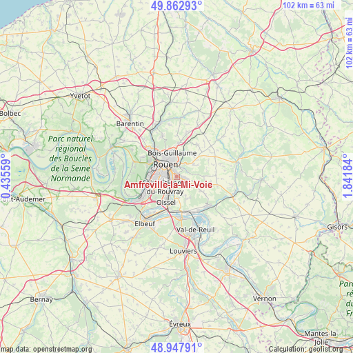
Amfreville-la-Mi-Voie GPS coordinates[2]
49° 24' 27.18" North, 1° 8' 19.356" East
| Map corner | latitude | longitude |
|---|---|---|
| Upper-left | 49.86293°, | 0.43559° |
| Center: | 49.40755°, | 1.13871° |
| Lower-right: | 48.94791°, | 1.84184° |
| Map W x H: | 101.7×101.7 km | = 63.2×63.2mi |
| max Lat: | 51.07786° ⇑12% North |
| Amfreville-la-Mi-Voie: | 49.40755° |
| min Lat: | ⇓88% South 41.3874° |
| min Long | Amfreville-la-M | max Long |
| -5.08615° | 1.13871° | 9.52242° |
| W 32.5%⇐ | ⇒67.5% E |
Elevation
Elevation of Amfreville-la-Mi-Voie is 150 m = 492 ft, and this is 43.7 m = 143 ft below average elevation for this country.
| Max E: |
2333 m = 7654 ft | 45% |
| Avg. | 193.7 m = 635 ft | |
| Amfreville-la-Mi-Voie | 150 m = 492 ft | |
Min E: |
-1 m = -3 ft | 55% |
See also: France elevation on elevation.city.
Geographical zone
Amfreville-la-Mi-Voie is located in North temperate zone (between Tropic of Cancer and the Arctic Circle). Distance of this North polar circle is 1907.6 km =1185.3 mi to North.| Distance of | km | miles | from Amfreville-la-Mi-Voie |
|---|---|---|---|
| North Pole | 4513.5 | 2804.6 | to North |
| Arctic Circle | 1907.6 | 1185.3 | to North |
| Tropic Cancer | 2887.7 | 1794.3 | to South |
| Equator | 5493.6 | 3413.6 | to South |


Nearby cities:
15 places around Amfreville-la-Mi-Voie: (largest is in red/bold)
• Belbeuf
2.2 km =1.4 mi,  173°
173°
• Bihorel
5.4 km =3.4 mi,  347°
347°
• Bois-Guillaume
6 km =3.7 mi, 348°
• Boos
5.1 km =3.2 mi,  114°
114°
• Darnétal
4.3 km =2.7 mi,  12°
12°
• Gouy
6 km =3.7 mi, 172°
• Le Mesnil-Esnard
0.8 km =0.5 mi,  36°
36°
• Le Petit-Quevilly
5.6 km =3.5 mi,  276°
276°
• Rouen
4.9 km =3 mi,  324°
324°
• Saint-Aubin-Celloville
5.1 km =3.2 mi,  162°
162°
• Saint-Aubin-Épinay
2.3 km =1.4 mi,  63°
63°
• Saint-Jacques-sur-Darnétal
5.9 km =3.7 mi,  52°
52°
• Saint-Léger-du-Bourg-Denis
3.2 km =2 mi,  25°
25°
• Saint-Étienne-du-Rouvray
4.1 km =2.5 mi,  216°
216°
• Sotteville-lès-Rouen
3.5 km =2.2 mi,  273°
273°
Sources, notices
• [Note1] Compared only with cities in France existing in our database
• [Src1] Map data: © OpenStreetMap contributors (CC-BY-SA)
• [Src2] Other city data from geonames.org with taken over terms of usage.
• [Src3] Geographical zone / Annual Mean Temperature by Robert A. Rohde @ Wikipedia
