Saint-Julien-de-Peyrolas geodata
Saint-Julien-de-Peyrolas (Occitanie) is a populated place; located in France in Europe/Paris (GMT+2) time zone. With population of 1,206 people, there are 7498 cities with bigger population in this country. Compared to other cities in France, 84.9% of cities are located further ↑North; 72.5% of cities are located further ←West and 58.7% of cities have higher elevation than Saint-Julien-de-Peyrolas. Note1
Administrative division(s):
- Level 1: Occitanie
- Level 2: Gard
- Level 3: Arrondissement de Nîmes
- Level 4: Saint-Julien-de-Peyrolas
Current local time in Saint-Julien-de-Peyrolas:
07:38 PM, SaturdayDifference from your time zone: hours


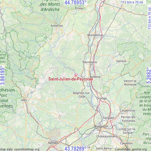
Saint-Julien-de-Peyrolas GPS coordinates[2]
44° 17' 18.132" North, 4° 33' 54.252" East
| Map corner | latitude | longitude |
|---|---|---|
| Upper-left | 44.78953°, | 3.86195° |
| Center: | 44.28837°, | 4.56507° |
| Lower-right: | 43.78289°, | 5.2682° |
| Map W x H: | 111.9×111.9 km | = 69.5×69.5mi |
| max Lat: | 51.07786° ⇑84.9% North |
| Saint-Julien-de-Peyrolas: | 44.28837° |
| min Lat: | ⇓15.1% South 41.3874° |
| min Long | Saint-Julien-de | max Long |
| -5.08615° | 4.56507° | 9.52242° |
| W 72.5%⇐ | ⇒27.5% E |
Elevation
Elevation of Saint-Julien-de-Peyrolas is 106 m = 348 ft, and this is 87.7 m = 288 ft below average elevation for this country.
| Max E: |
2333 m = 7654 ft | 58.7% |
| Avg. | 193.7 m = 635 ft | |
| Saint-Julien-de-Peyrolas | 106 m = 348 ft | |
Min E: |
-1 m = -3 ft | 41.3% |
See also: France elevation on elevation.city.
Geographical zone
Saint-Julien-de-Peyrolas is located in North temperate zone (between Tropic of Cancer and the Arctic Circle). Distance of this Northern Tropic circle is 2318.5 km =1440.6 mi to South.| Distance of | km | miles | from Saint-Julien-de-Peyrolas |
|---|---|---|---|
| North Pole | 5082.7 | 3158.2 | to North |
| Arctic Circle | 2476.8 | 1539 | to North |
| Tropic Cancer | 2318.5 | 1440.6 | to South |
| Equator | 4924.4 | 3059.9 | to South |


Nearby cities:
15 places around Saint-Julien-de-Peyrolas: (largest is in red/bold)
• Bourg-Saint-Andéol
11.4 km =7.1 mi,  33°
33°
• Carsan
6.5 km =4 mi,  157°
157°
• Cornillon
9.3 km =5.8 mi,  220°
220°
• Goudargues
11.4 km =7.1 mi, 223°
• Lapalud
10.1 km =6.3 mi,  77°
77°
• Mondragon
13 km =8.1 mi,  115°
115°
• Pont-Saint-Esprit
7.5 km =4.7 mi, 119°
• Saint-Alexandre
8.1 km =5 mi,  146°
146°
• Saint-Gervais
11.7 km =7.3 mi,  175°
175°
• Saint-Just-d'Ardèche
4.3 km =2.7 mi,  72°
72°
• Saint-Marcel-d'Ardèche
6 km =3.7 mi,  44°
44°
• Saint-Nazaire
11.1 km =6.9 mi, 154°
• Saint-Paulet-de-Caisson
4 km =2.5 mi,  139°
139°
• Saint-Remèze
12.6 km =7.8 mi,  336°
336°
• Vénéjan
12.4 km =7.7 mi, 144°
Sources, notices
• [Note1] Compared only with cities in France existing in our database
• [Src1] Map data: © OpenStreetMap contributors (CC-BY-SA)
• [Src2] Other city data from geonames.org with taken over terms of usage.
• [Src3] Geographical zone / Annual Mean Temperature by Robert A. Rohde @ Wikipedia
