Gimel-les-Cascades geodata
Gimel-les-Cascades (Nouvelle-Aquitaine) is a populated place; located in France in Europe/Paris (GMT+2) time zone. With population of 658 people, there are 12412 cities with bigger population in this country. Compared to other cities in France, 76.3% of cities are located further ↑North; 58.8% of cities are located further →East and 90.4% of cities have lower elevation than Gimel-les-Cascades. Note1
Administrative division(s):
- Level 1: Nouvelle-Aquitaine
- Level 2: Département de la Corrèze
- Level 3: Arrondissement de Tulle
- Level 4: Gimel-les-Cascades


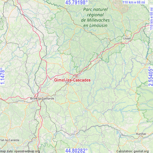
Gimel-les-Cascades GPS coordinates[2]
45° 17' 58.416" North, 1° 51' 3.312" East
| Map corner | latitude | longitude |
|---|---|---|
| Upper-left | 45.79198°, | 1.1478° |
| Center: | 45.29956°, | 1.85092° |
| Lower-right: | 44.80282°, | 2.55405° |
| Map W x H: | 110×110 km | = 68.4×68.4mi |
| max Lat: | 51.07786° ⇑76.3% North |
| Gimel-les-Cascades: | 45.29956° |
| min Lat: | ⇓23.7% South 41.3874° |
| min Long | Gimel-les-Casca | max Long |
| -5.08615° | 1.85092° | 9.52242° |
| W 41.2%⇐ | ⇒58.8% E |
Elevation
Elevation of Gimel-les-Cascades is 436 m = 1430 ft, and this is 242.3 m = 795 ft above average elevation for this country.
| Max E: |
2333 m = 7654 ft | 9.6% |
| Gimel-les-Cascades | 436 m 1430 ft | |
| Avg. | 193.7 m = 635 ft | |
Min E: |
-1 m = -3 ft | 90.4% |
See also: France elevation on elevation.city.
Geographical zone
Gimel-les-Cascades is located in North temperate zone (between Tropic of Cancer and the Arctic Circle). Distance of this North polar circle is 2364.3 km =1469.1 mi to North.| Distance of | km | miles | from Gimel-les-Cascades |
|---|---|---|---|
| North Pole | 4970.2 | 3088.3 | to North |
| Arctic Circle | 2364.3 | 1469.1 | to North |
| Tropic Cancer | 2430.9 | 1510.5 | to South |
| Equator | 5036.8 | 3129.7 | to South |


Nearby cities:
15 places around Gimel-les-Cascades: (largest is in red/bold)
• Chameyrat
14 km =8.7 mi,  238°
238°
• Chanac-les-Mines
4.6 km =2.9 mi,  212°
212°
• Cornil
15.9 km =9.9 mi,  231°
231°
• Corrèze
8.3 km =5.2 mi,  13°
13°
• Eyrein
8.3 km =5.2 mi,  61°
61°
• Lagarde-Enval
13 km =8.1 mi,  195°
195°
• Laguenne
8.4 km =5.2 mi,  220°
220°
• Marcillac-la-Croisille
14.3 km =8.9 mi,  102°
102°
• Naves
6.7 km =4.2 mi,  283°
283°
• Saint-Clément
13.8 km =8.6 mi,  289°
289°
• Saint-Hippolyte
13.9 km =8.6 mi, 63°
• Saint-Mexant
15.2 km =9.4 mi,  263°
263°
• Sainte-Fortunade
12 km =7.5 mi, 211°
• Seilhac
13.1 km =8.1 mi,  304°
304°
• Tulle
7.2 km =4.5 mi, 238°
In other languages:
- In France: Gimel-les-Cascades, Gimel
- In Russian: Жимель-ле-Каскад
- In Chinese: 吉梅莱卡斯卡代
Sources, notices
• [Note1] Compared only with cities in France existing in our database
• [Src1] Map data: © OpenStreetMap contributors (CC-BY-SA)
• [Src2] Other city data from geonames.org with taken over terms of usage.
• [Src3] Geographical zone / Annual Mean Temperature by Robert A. Rohde @ Wikipedia
