Saint-Hippolyte geodata
Saint-Hippolyte (Nouvelle-Aquitaine) is a populated place; located in France in Europe/Paris (GMT+2) time zone. With population of 584 people, there are 13570 cities with bigger population in this country. Compared to other cities in France, 75.8% of cities are located further ↑North; 57% of cities are located further →East and 94.7% of cities have lower elevation than Saint-Hippolyte. Note1
Administrative division(s):
- Level 1: Nouvelle-Aquitaine
- Level 2: Département de la Corrèze
- Level 3: Ussel
- Level 4: Montaignac-Saint-Hippolyte


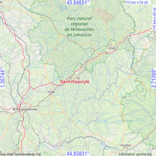
Saint-Hippolyte GPS coordinates[2]
45° 21' 16.452" North, 2° 0' 38.016" East
| Map corner | latitude | longitude |
|---|---|---|
| Upper-left | 45.84651°, | 1.30744° |
| Center: | 45.35457°, | 2.01056° |
| Lower-right: | 44.85831°, | 2.71369° |
| Map W x H: | 109.9×109.9 km | = 68.3×68.3mi |
| max Lat: | 51.07786° ⇑75.8% North |
| Saint-Hippolyte: | 45.35457° |
| min Lat: | ⇓24.2% South 41.3874° |
| min Long | Saint-Hippolyte | max Long |
| -5.08615° | 2.01056° | 9.52242° |
| W 43%⇐ | ⇒57% E |
Elevation
Elevation of Saint-Hippolyte is 569 m = 1867 ft, and this is 375.3 m = 1231 ft above average elevation for this country.
| Max E: |
2333 m = 7654 ft | 5.3% |
| Saint-Hippolyte | 569 m 1867 ft | |
| Avg. | 193.7 m = 635 ft | |
Min E: |
-1 m = -3 ft | 94.7% |
See also: France elevation on elevation.city.
Geographical zone
Saint-Hippolyte is located in North temperate zone (between Tropic of Cancer and the Arctic Circle). Distance of this North polar circle is 2358.2 km =1465.3 mi to North.| Distance of | km | miles | from Saint-Hippolyte |
|---|---|---|---|
| North Pole | 4964.1 | 3084.5 | to North |
| Arctic Circle | 2358.2 | 1465.3 | to North |
| Tropic Cancer | 2437 | 1514.3 | to South |
| Equator | 5043 | 3133.6 | to South |


Nearby cities:
15 places around Saint-Hippolyte: (largest is in red/bold)
• Chanac-les-Mines
18 km =11.2 mi,  236°
236°
• Corrèze
10.8 km =6.7 mi,  280°
280°
• Eyrein
5.6 km =3.5 mi,  247°
247°
• Gimel-les-Cascades
13.9 km =8.6 mi, 243°
• Lagarde-Enval
24.5 km =15.2 mi,  220°
220°
• Laguenne
21.9 km =13.6 mi, 235°
• Marcillac-la-Croisille
9.3 km =5.8 mi,  170°
170°
• Meymac
22.8 km =14.2 mi,  27°
27°
• Naves
19.6 km =12.2 mi,  256°
256°
• Neuvic
20.6 km =12.8 mi,  81°
81°
• Saint-Angel
23.9 km =14.9 mi,  46°
46°
• Seilhac
23.2 km =14.4 mi,  273°
273°
• Soursac
17.3 km =10.7 mi,  120°
120°
• Tulle
21.1 km =13.1 mi, 242°
• Égletons
6.4 km =4 mi, 25°
Sources, notices
• [Note1] Compared only with cities in France existing in our database
• [Src1] Map data: © OpenStreetMap contributors (CC-BY-SA)
• [Src2] Other city data from geonames.org with taken over terms of usage.
• [Src3] Geographical zone / Annual Mean Temperature by Robert A. Rohde @ Wikipedia
