Corrèze geodata
Corrèze (Nouvelle-Aquitaine) is a populated place; located in France in Europe/Paris (GMT+2) time zone. With population of 1,176 people, there are 7669 cities with bigger population in this country. Compared to other cities in France, 75.6% of cities are located further ↑North; 58.6% of cities are located further →East and 92% of cities have lower elevation than Corrèze. Note1
Administrative division(s):
- Level 1: Nouvelle-Aquitaine
- Level 2: Département de la Corrèze
- Level 3: Arrondissement de Tulle
- Level 4: Corrèze


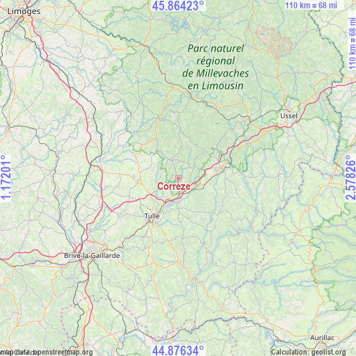
Corrèze GPS coordinates[2]
45° 22' 20.784" North, 1° 52' 30.468" East
| Map corner | latitude | longitude |
|---|---|---|
| Upper-left | 45.86423°, | 1.17201° |
| Center: | 45.37244°, | 1.87513° |
| Lower-right: | 44.87634°, | 2.57826° |
| Map W x H: | 109.8×109.8 km | = 68.2×68.2mi |
| max Lat: | 51.07786° ⇑75.6% North |
| Corrèze: | 45.37244° |
| min Lat: | ⇓24.4% South 41.3874° |
| min Long | Corrèze | max Long |
| -5.08615° | 1.87513° | 9.52242° |
| W 41.4%⇐ | ⇒58.6% E |
Elevation
Elevation of Corrèze is 477 m = 1565 ft, and this is 283.3 m = 929 ft above average elevation for this country.
| Max E: |
2333 m = 7654 ft | 8% |
| Corrèze | 477 m 1565 ft | |
| Avg. | 193.7 m = 635 ft | |
Min E: |
-1 m = -3 ft | 92% |
See also: France elevation on elevation.city.
Geographical zone
Corrèze is located in North temperate zone (between Tropic of Cancer and the Arctic Circle). Distance of this North polar circle is 2356.2 km =1464.1 mi to North.| Distance of | km | miles | from Corrèze |
|---|---|---|---|
| North Pole | 4962.1 | 3083.3 | to North |
| Arctic Circle | 2356.2 | 1464.1 | to North |
| Tropic Cancer | 2439 | 1515.5 | to South |
| Equator | 5044.9 | 3134.8 | to South |


Nearby cities:
15 places around Corrèze: (largest is in red/bold)
• Chamboulive
14.9 km =9.3 mi,  296°
296°
• Chanac-les-Mines
12.8 km =8 mi,  199°
199°
• Eyrein
6.8 km =4.2 mi,  127°
127°
• Gimel-les-Cascades
8.3 km =5.2 mi,  193°
193°
• Lagraulière
18.6 km =11.6 mi,  263°
263°
• Laguenne
16.2 km =10.1 mi,  206°
206°
• Le Lonzac
15.3 km =9.5 mi,  311°
311°
• Marcillac-la-Croisille
16.4 km =10.2 mi, 132°
• Naves
10.7 km =6.6 mi,  232°
232°
• Saint-Clément
15.2 km =9.4 mi, 256°
• Saint-Hippolyte
10.8 km =6.7 mi,  100°
100°
• Saint-Jal
18.3 km =11.4 mi,  278°
278°
• Seilhac
12.6 km =7.8 mi,  267°
267°
• Tulle
14.3 km =8.9 mi, 214°
• Égletons
13.8 km =8.6 mi,  74°
74°
Sources, notices
• [Note1] Compared only with cities in France existing in our database
• [Src1] Map data: © OpenStreetMap contributors (CC-BY-SA)
• [Src2] Other city data from geonames.org with taken over terms of usage.
• [Src3] Geographical zone / Annual Mean Temperature by Robert A. Rohde @ Wikipedia
