Fussy geodata
Fussy (Centre) is a populated place; located in France in Europe/Paris (GMT+2) time zone. With population of 1,977 people, there are 4837 cities with bigger population in this country. Compared to other cities in France, 53.7% of cities are located further ↑North; 50.6% of cities are located further →East and 56.3% of cities have lower elevation than Fussy. Note1
Administrative division(s):
- Level 1: Centre
- Level 2: Cher
- Level 3: Arrondissement de Bourges
- Level 4: Fussy


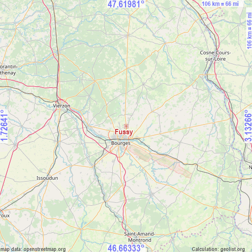
Fussy GPS coordinates[2]
47° 8' 37.392" North, 2° 25' 46.308" East
| Map corner | latitude | longitude |
|---|---|---|
| Upper-left | 47.61981°, | 1.72641° |
| Center: | 47.14372°, | 2.42953° |
| Lower-right: | 46.66333°, | 3.13266° |
| Map W x H: | 106.4×106.3 km | = 66.1×66.1mi |
| max Lat: | 51.07786° ⇑53.7% North |
| Fussy: | 47.14372° |
| min Lat: | ⇓46.3% South 41.3874° |
| min Long | Fussy | max Long |
| -5.08615° | 2.42953° | 9.52242° |
| W 49.4%⇐ | ⇒50.6% E |
Elevation
Elevation of Fussy is 155 m = 509 ft, and this is 38.7 m = 127 ft below average elevation for this country.
| Max E: |
2333 m = 7654 ft | 43.7% |
| Avg. | 193.7 m = 635 ft | |
| Fussy | 155 m = 509 ft | |
Min E: |
-1 m = -3 ft | 56.3% |
See also: France elevation on elevation.city.
Geographical zone
Fussy is located in North temperate zone (between Tropic of Cancer and the Arctic Circle). Distance of this North polar circle is 2159.3 km =1341.7 mi to North.| Distance of | km | miles | from Fussy |
|---|---|---|---|
| North Pole | 4765.2 | 2961 | to North |
| Arctic Circle | 2159.3 | 1341.7 | to North |
| Tropic Cancer | 2636 | 1637.9 | to South |
| Equator | 5241.9 | 3257.2 | to South |


Nearby cities:
15 places around Fussy: (largest is in red/bold)
• Berry-Bouy
11.3 km =7 mi,  250°
250°
• Bourges
7.1 km =4.4 mi,  198°
198°
• La Chapelle-Saint-Ursin
12 km =7.5 mi,  221°
221°
• Les Aix-d’Angillon
11.8 km =7.3 mi,  60°
60°
• Menetou-Salon
10.7 km =6.6 mi,  23°
23°
• Pigny
3.7 km =2.3 mi,  12°
12°
• Saint-Doulchard
7.4 km =4.6 mi,  232°
232°
• Saint-Georges-sur-Moulon
5.2 km =3.2 mi,  354°
354°
• Saint-Germain-du-Puy
6.3 km =3.9 mi,  140°
140°
• Saint-Martin-d’Auxigny
6.8 km =4.2 mi, 350°
• Saint-Palais
9.9 km =6.2 mi,  355°
355°
• Saint-Éloy-de-Gy
6.7 km =4.2 mi,  281°
281°
• Sainte-Solange
9.2 km =5.7 mi,  95°
95°
• Vasselay
3.4 km =2.1 mi,  295°
295°
• Vignoux-sous-les-Aix
5.6 km =3.5 mi,  28°
28°
Sources, notices
• [Note1] Compared only with cities in France existing in our database
• [Src1] Map data: © OpenStreetMap contributors (CC-BY-SA)
• [Src2] Other city data from geonames.org with taken over terms of usage.
• [Src3] Geographical zone / Annual Mean Temperature by Robert A. Rohde @ Wikipedia
