Fauillet geodata
Fauillet (Nouvelle-Aquitaine) is a populated place; located in France in Europe/Paris (GMT+2) time zone. With population of 869 people, there are 9902 cities with bigger population in this country. Compared to other cities in France, 84.1% of cities are located further ↑North; 75.4% of cities are located further →East and 86.7% of cities have higher elevation than Fauillet. Note1
Administrative division(s):
- Level 1: Nouvelle-Aquitaine
- Level 2: Département du Lot-et-Garonne
- Level 3: Arrondissement de Marmande
- Level 4: Fauillet


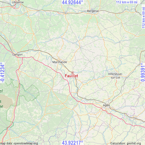
Fauillet GPS coordinates[2]
44° 25' 35.256" North, 0° 17' 26.844" East
| Map corner | latitude | longitude |
|---|---|---|
| Upper-left | 44.92644°, | -0.41234° |
| Center: | 44.42646°, | 0.29079° |
| Lower-right: | 43.92217°, | 0.99391° |
| Map W x H: | 111.7×111.7 km | = 69.4×69.4mi |
| max Lat: | 51.07786° ⇑84.1% North |
| Fauillet: | 44.42646° |
| min Lat: | ⇓15.9% South 41.3874° |
| min Long | Fauillet | max Long |
| -5.08615° | 0.29079° | 9.52242° |
| W 24.6%⇐ | ⇒75.4% E |
Elevation
Elevation of Fauillet is 38 m = 125 ft, and this is 155.7 m = 511 ft below average elevation for this country.
| Max E: |
2333 m = 7654 ft | 86.7% |
| Avg. | 193.7 m = 635 ft | |
| Fauillet | 38 m = 125 ft | |
Min E: |
-1 m = -3 ft | 13.3% |
See also: France elevation on elevation.city.
Geographical zone
Fauillet is located in North temperate zone (between Tropic of Cancer and the Arctic Circle). Distance of this Northern Tropic circle is 2333.8 km =1450.2 mi to South.| Distance of | km | miles | from Fauillet |
|---|---|---|---|
| North Pole | 5067.3 | 3148.7 | to North |
| Arctic Circle | 2461.4 | 1529.4 | to North |
| Tropic Cancer | 2333.8 | 1450.2 | to South |
| Equator | 4939.8 | 3069.4 | to South |


Nearby cities:
15 places around Fauillet: (largest is in red/bold)
• Birac-sur-Trec
6.8 km =4.2 mi,  343°
343°
• Bourran
12.4 km =7.7 mi,  138°
138°
• Calonges
7 km =4.3 mi,  213°
213°
• Caumont-sur-Garonne
8.8 km =5.5 mi,  278°
278°
• Clairac
10.2 km =6.3 mi, 136°
• Fauguerolles
3.7 km =2.3 mi,  298°
298°
• Fourques-sur-Garonne
10.9 km =6.8 mi, 282°
• Gontaud-de-Nogaret
2.7 km =1.7 mi,  15°
15°
• Le Mas-d’Agenais
6 km =3.7 mi,  252°
252°
• Puymiclan
9.8 km =6.1 mi,  11°
11°
• Saint-Pardoux-du-Breuil
9.4 km =5.8 mi,  305°
305°
• Tonneins
4.2 km =2.6 mi,  155°
155°
• Varès
5.4 km =3.4 mi,  86°
86°
• Villeton
5.8 km =3.6 mi,  182°
182°
• Virazeil
10.5 km =6.5 mi,  328°
328°
Sources, notices
• [Note1] Compared only with cities in France existing in our database
• [Src1] Map data: © OpenStreetMap contributors (CC-BY-SA)
• [Src2] Other city data from geonames.org with taken over terms of usage.
• [Src3] Geographical zone / Annual Mean Temperature by Robert A. Rohde @ Wikipedia
