Jausiers geodata
Jausiers (Provence-Alpes-Côte d'Azur) is a populated place; located in France in Europe/Paris (GMT+2) time zone. With population of 1,026 people, there are 8645 cities with bigger population in this country. Compared to other cities in France, 84.1% of cities are located further ↑North; 93.2% of cities are located further ←West and 99.7% of cities have lower elevation than Jausiers. Note1
Administrative division(s):
- Level 1: Provence-Alpes-Côte d'Azur
- Level 2: Alpes-de-Haute-Provence
- Level 3: Arrondissement de Barcelonnette
- Level 4: Jausiers


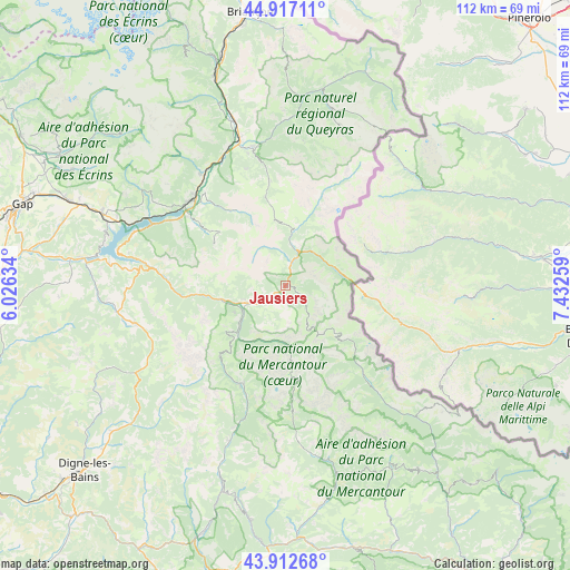
Jausiers GPS coordinates[2]
44° 25' 1.38" North, 6° 43' 46.092" East
| Map corner | latitude | longitude |
|---|---|---|
| Upper-left | 44.91711°, | 6.02634° |
| Center: | 44.41705°, | 6.72947° |
| Lower-right: | 43.91268°, | 7.43259° |
| Map W x H: | 111.7×111.7 km | = 69.4×69.4mi |
| max Lat: | 51.07786° ⇑84.1% North |
| Jausiers: | 44.41705° |
| min Lat: | ⇓15.9% South 41.3874° |
| min Long | Jausiers | max Long |
| -5.08615° | 6.72947° | 9.52242° |
| W 93.2%⇐ | ⇒6.8% E |
Elevation
Elevation of Jausiers is 1214 m = 3983 ft, and this is 1020.3 m = 3347 ft above average elevation for this country.
| Max E: |
2333 m = 7654 ft | 0.3% |
| Jausiers | 1214 m 3983 ft | |
| Avg. | 193.7 m = 635 ft | |
Min E: |
-1 m = -3 ft | 99.7% |
See also: France elevation on elevation.city.
Geographical zone
Jausiers is located in North temperate zone (between Tropic of Cancer and the Arctic Circle). Distance of this Northern Tropic circle is 2332.8 km =1449.5 mi to South.| Distance of | km | miles | from Jausiers |
|---|---|---|---|
| North Pole | 5068.3 | 3149.3 | to North |
| Arctic Circle | 2462.5 | 1530.1 | to North |
| Tropic Cancer | 2332.8 | 1449.5 | to South |
| Equator | 4938.7 | 3068.8 | to South |


Nearby cities:
15 places around Jausiers: (largest is in red/bold)
• Allos
21.1 km =13.1 mi,  202°
202°
• Barcelonnette
7 km =4.3 mi,  241°
241°
• Châteauroux-les-Alpes
27.5 km =17.1 mi,  323°
323°
• Embrun
24.7 km =15.3 mi,  311°
311°
• Enchastrayes
6.2 km =3.9 mi,  206°
206°
• Guillaumes
37.6 km =23.4 mi,  164°
164°
• Guillestre
27.7 km =17.2 mi,  346°
346°
• Isola
36.4 km =22.6 mi,  134°
134°
• Péone
36.3 km =22.6 mi, 157°
• Risoul
26.7 km =16.6 mi,  344°
344°
• Saint-Crépin
33.6 km =20.9 mi, 343°
• Saint-Étienne-de-Tinée
23.7 km =14.7 mi,  138°
138°
• Savines-le-Lac
28.5 km =17.7 mi,  295°
295°
• Seyne-les-Alpes
30.6 km =19 mi,  255°
255°
• Vars
20.3 km =12.6 mi, 351°
Sources, notices
• [Note1] Compared only with cities in France existing in our database
• [Src1] Map data: © OpenStreetMap contributors (CC-BY-SA)
• [Src2] Other city data from geonames.org with taken over terms of usage.
• [Src3] Geographical zone / Annual Mean Temperature by Robert A. Rohde @ Wikipedia
