Espinasses geodata
Espinasses (Provence-Alpes-Côte d'Azur) is a populated place; located in France in Europe/Paris (GMT+2) time zone. With population of 633 people, there are 12771 cities with bigger population in this country. Compared to other cities in France, 83.8% of cities are located further ↑North; 89.6% of cities are located further ←West and 96.5% of cities have lower elevation than Espinasses. Note1
Administrative division(s):
- Level 1: Provence-Alpes-Côte d'Azur
- Level 2: Hautes-Alpes
- Level 3: Arrondissement de Gap
- Level 4: Espinasses


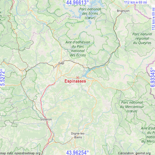
Espinasses GPS coordinates[2]
44° 27' 59.364" North, 6° 13' 49.152" East
| Map corner | latitude | longitude |
|---|---|---|
| Upper-left | 44.96613°, | 5.5272° |
| Center: | 44.46649°, | 6.23032° |
| Lower-right: | 43.96254°, | 6.93345° |
| Map W x H: | 111.6×111.6 km | = 69.3×69.3mi |
| max Lat: | 51.07786° ⇑83.8% North |
| Espinasses: | 44.46649° |
| min Lat: | ⇓16.2% South 41.3874° |
| min Long | Espinasses | max Long |
| -5.08615° | 6.23032° | 9.52242° |
| W 89.6%⇐ | ⇒10.4% E |
Elevation
Elevation of Espinasses is 681 m = 2234 ft, and this is 487.3 m = 1599 ft above average elevation for this country.
| Max E: |
2333 m = 7654 ft | 3.5% |
| Espinasses | 681 m 2234 ft | |
| Avg. | 193.7 m = 635 ft | |
Min E: |
-1 m = -3 ft | 96.5% |
See also: France elevation on elevation.city.
Geographical zone
Espinasses is located in North temperate zone (between Tropic of Cancer and the Arctic Circle). Distance of this Northern Tropic circle is 2338.3 km =1453 mi to South.| Distance of | km | miles | from Espinasses |
|---|---|---|---|
| North Pole | 5062.9 | 3145.9 | to North |
| Arctic Circle | 2457 | 1526.7 | to North |
| Tropic Cancer | 2338.3 | 1453 | to South |
| Equator | 4944.2 | 3072.2 | to South |


Nearby cities:
15 places around Espinasses: (largest is in red/bold)
• Ancelle
17.5 km =10.9 mi,  353°
353°
• Chabottes
21.3 km =13.2 mi, 348°
• Chorges
9.9 km =6.2 mi,  22°
22°
• Embrun
23.6 km =14.7 mi,  62°
62°
• Gap
15.8 km =9.8 mi,  310°
310°
• La Bâtie-Neuve
11.5 km =7.1 mi, 346°
• La Motte-du-Caire
21.1 km =13.1 mi,  229°
229°
• La Roche-des-Arnauds
24.2 km =15 mi,  295°
295°
• La Saulce
18.3 km =11.4 mi,  255°
255°
• Neffes
17.1 km =10.6 mi,  284°
284°
• Saint-Jean
22.7 km =14.1 mi,  357°
357°
• Savines-le-Lac
15.3 km =9.5 mi, 64°
• Seyne-les-Alpes
16.3 km =10.1 mi,  142°
142°
• Sigoyer
20.2 km =12.6 mi,  273°
273°
• Tallard
14.2 km =8.8 mi, 267°
Sources, notices
• [Note1] Compared only with cities in France existing in our database
• [Src1] Map data: © OpenStreetMap contributors (CC-BY-SA)
• [Src2] Other city data from geonames.org with taken over terms of usage.
• [Src3] Geographical zone / Annual Mean Temperature by Robert A. Rohde @ Wikipedia
