Cologne geodata
Cologne (Occitanie) is a populated place; located in France in Europe/Paris (GMT+2) time zone. With population of 728 people, there are 11431 cities with bigger population in this country. Compared to other cities in France, 90.1% of cities are located further ↑North; 69% of cities are located further →East and 66.8% of cities have lower elevation than Cologne. Note1
Administrative division(s):
- Level 1: Occitanie
- Level 2: Gers
- Level 3: Arrondissement de Condom
- Level 4: Cologne


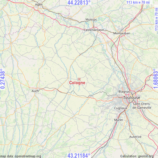
Cologne GPS coordinates[2]
43° 43' 19.704" North, 0° 58' 39" East
| Map corner | latitude | longitude |
|---|---|---|
| Upper-left | 44.22813°, | 0.27438° |
| Center: | 43.72214°, | 0.9775° |
| Lower-right: | 43.21184°, | 1.68063° |
| Map W x H: | 113×113 km | = 70.2×70.2mi |
| max Lat: | 51.07786° ⇑90.1% North |
| Cologne: | 43.72214° |
| min Lat: | ⇓9.9% South 41.3874° |
| min Long | Cologne | max Long |
| -5.08615° | 0.9775° | 9.52242° |
| W 31%⇐ | ⇒69% E |
Elevation
Elevation of Cologne is 203 m = 666 ft, and this is 9.3 m = 31 ft above average elevation for this country.
| Max E: |
2333 m = 7654 ft | 33.2% |
| Cologne | 203 m 666 ft | |
| Avg. | 193.7 m = 635 ft | |
Min E: |
-1 m = -3 ft | 66.8% |
See also: France elevation on elevation.city.
Geographical zone
Cologne is located in North temperate zone (between Tropic of Cancer and the Arctic Circle). Distance of this Northern Tropic circle is 2255.5 km =1401.5 mi to South.| Distance of | km | miles | from Cologne |
|---|---|---|---|
| North Pole | 5145.6 | 3197.3 | to North |
| Arctic Circle | 2539.7 | 1578.1 | to North |
| Tropic Cancer | 2255.5 | 1401.5 | to South |
| Equator | 4861.4 | 3020.7 | to South |


Nearby cities:
15 places around Cologne: (largest is in red/bold)
• Aubiet
17.7 km =11 mi,  241°
241°
• Beaumont-de-Lomagne
17.9 km =11.1 mi,  2°
2°
• Cadours
5.9 km =3.7 mi,  83°
83°
• Escornebœuf
10.2 km =6.3 mi,  217°
217°
• Gimont
13.4 km =8.3 mi, 217°
• Lasserre
17.9 km =11.1 mi,  121°
121°
• Launac
16.6 km =10.3 mi, 81°
• Le Castéra
14.2 km =8.8 mi,  112°
112°
• L’Isle-Jourdain
14.8 km =9.2 mi,  145°
145°
• Marignac
14.6 km =9.1 mi,  338°
338°
• Mauvezin
8 km =5 mi,  276°
276°
• Monferran-Savès
13.8 km =8.6 mi,  179°
179°
• Ségoufielle
16 km =9.9 mi,  129°
129°
• Thil
14.6 km =9.1 mi,  94°
94°
• Touget
6.2 km =3.9 mi,  234°
234°
Sources, notices
• [Note1] Compared only with cities in France existing in our database
• [Src1] Map data: © OpenStreetMap contributors (CC-BY-SA)
• [Src2] Other city data from geonames.org with taken over terms of usage.
• [Src3] Geographical zone / Annual Mean Temperature by Robert A. Rohde @ Wikipedia
