Escornebœuf geodata
Escornebœuf (Occitanie) is a populated place; located in France in Europe/Paris (GMT+2) time zone. With population of 526 people, there are 14691 cities with bigger population in this country. Compared to other cities in France, 91.2% of cities are located further ↑North; 69.7% of cities are located further →East and 59.6% of cities have lower elevation than Escornebœuf. Note1


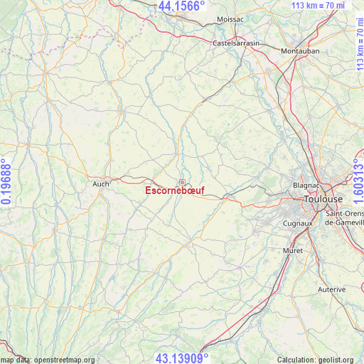
Escornebœuf GPS coordinates[2]
43° 39' 0" North, 0° 54' 0" East
| Map corner | latitude | longitude |
|---|---|---|
| Upper-left | 44.1566°, | 0.19688° |
| Center: | 43.65°, | 0.9° |
| Lower-right: | 43.13909°, | 1.60313° |
| Map W x H: | 113.1×113.1 km | = 70.3×70.3mi |
| max Lat: | 51.07786° ⇑91.2% North |
| Escornebœuf: | 43.65° |
| min Lat: | ⇓8.8% South 41.3874° |
| min Long | Escornebœuf | max Long |
| -5.08615° | 0.9° | 9.52242° |
| W 30.3%⇐ | ⇒69.7% E |
Elevation
Elevation of Escornebœuf is 168 m = 551 ft, and this is 25.7 m = 84 ft below average elevation for this country.
| Max E: |
2333 m = 7654 ft | 40.4% |
| Avg. | 193.7 m = 635 ft | |
| Escornebœuf | 168 m = 551 ft | |
Min E: |
-1 m = -3 ft | 59.6% |
See also: France elevation on elevation.city.
Geographical zone
Escornebœuf is located in North temperate zone (between Tropic of Cancer and the Arctic Circle). Distance of this Northern Tropic circle is 2247.5 km =1396.5 mi to South.| Distance of | km | miles | from Escornebœuf |
|---|---|---|---|
| North Pole | 5153.6 | 3202.3 | to North |
| Arctic Circle | 2547.7 | 1583.1 | to North |
| Tropic Cancer | 2247.5 | 1396.5 | to South |
| Equator | 4853.4 | 3015.8 | to South |


Nearby cities:
15 places around Escornebœuf: (largest is in red/bold)
• Aubiet
9.3 km =5.8 mi,  267°
267°
• Auradé
15.8 km =9.8 mi,  126°
126°
• Cadours
14.9 km =9.3 mi,  54°
54°
• Cologne
10.2 km =6.3 mi,  37°
37°
• Endoufielle
14.6 km =9.1 mi,  139°
139°
• Gimont
3.2 km =2 mi,  215°
215°
• Le Castéra
19.5 km =12.1 mi,  82°
82°
• Lombez
19.5 km =12.1 mi,  177°
177°
• L’Isle-Jourdain
15.3 km =9.5 mi,  106°
106°
• Mauvezin
9.1 km =5.7 mi,  348°
348°
• Monferran-Savès
8.7 km =5.4 mi, 131°
• Samatan
17.6 km =10.9 mi,  172°
172°
• Saramon
17.9 km =11.1 mi, 217°
• Ségoufielle
18.8 km =11.7 mi,  96°
96°
• Touget
4.6 km =2.9 mi,  14°
14°
Sources, notices
• [Note1] Compared only with cities in France existing in our database
• [Src1] Map data: © OpenStreetMap contributors (CC-BY-SA)
• [Src2] Other city data from geonames.org with taken over terms of usage.
• [Src3] Geographical zone / Annual Mean Temperature by Robert A. Rohde @ Wikipedia
