Gimont geodata
Gimont (Occitanie) is a populated place; located in France in Europe/Paris (GMT+2) time zone. With population of 2,852 people, there are 3421 cities with bigger population in this country. Compared to other cities in France, 91.5% of cities are located further ↑North; 69.9% of cities are located further →East and 62.7% of cities have lower elevation than Gimont. Note1


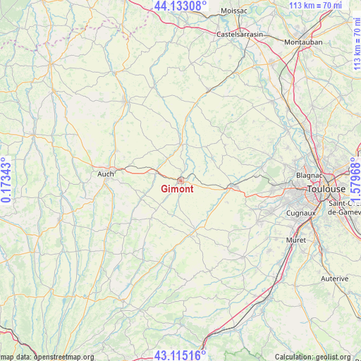
Gimont GPS coordinates[2]
43° 37' 34.572" North, 0° 52' 35.58" East
| Map corner | latitude | longitude |
|---|---|---|
| Upper-left | 44.13308°, | 0.17343° |
| Center: | 43.62627°, | 0.87655° |
| Lower-right: | 43.11516°, | 1.57968° |
| Map W x H: | 113.2×113.2 km | = 70.3×70.3mi |
| max Lat: | 51.07786° ⇑91.5% North |
| Gimont: | 43.62627° |
| min Lat: | ⇓8.5% South 41.3874° |
| min Long | Gimont | max Long |
| -5.08615° | 0.87655° | 9.52242° |
| W 30.1%⇐ | ⇒69.9% E |
Elevation
Elevation of Gimont is 183 m = 600 ft, and this is 10.7 m = 35 ft below average elevation for this country.
| Max E: |
2333 m = 7654 ft | 37.3% |
| Avg. | 193.7 m = 635 ft | |
| Gimont | 183 m = 600 ft | |
Min E: |
-1 m = -3 ft | 62.7% |
See also: France elevation on elevation.city.
Geographical zone
Gimont is located in North temperate zone (between Tropic of Cancer and the Arctic Circle). Distance of this Northern Tropic circle is 2244.9 km =1394.9 mi to South.| Distance of | km | miles | from Gimont |
|---|---|---|---|
| North Pole | 5156.3 | 3204 | to North |
| Arctic Circle | 2550.4 | 1584.7 | to North |
| Tropic Cancer | 2244.9 | 1394.9 | to South |
| Equator | 4850.8 | 3014.1 | to South |


Nearby cities:
15 places around Gimont: (largest is in red/bold)
• Aubiet
7.7 km =4.8 mi,  286°
286°
• Auradé
16.1 km =10 mi,  114°
114°
• Cadours
18 km =11.2 mi,  50°
50°
• Cologne
13.4 km =8.3 mi,  37°
37°
• Endoufielle
14.1 km =8.8 mi,  126°
126°
• Escornebœuf
3.2 km =2 mi, 35°
• Lombez
17 km =10.6 mi,  170°
170°
• L’Isle-Jourdain
16.6 km =10.3 mi,  95°
95°
• Mauvezin
11.6 km =7.2 mi,  0°
0°
• Monferran-Savès
8.9 km =5.5 mi, 110°
• Pessan
18.4 km =11.4 mi,  268°
268°
• Samatan
15.4 km =9.6 mi,  163°
163°
• Saramon
14.6 km =9.1 mi,  218°
218°
• Ségoufielle
20.5 km =12.7 mi,  88°
88°
• Touget
7.7 km =4.8 mi,  23°
23°
Sources, notices
• [Note1] Compared only with cities in France existing in our database
• [Src1] Map data: © OpenStreetMap contributors (CC-BY-SA)
• [Src2] Other city data from geonames.org with taken over terms of usage.
• [Src3] Geographical zone / Annual Mean Temperature by Robert A. Rohde @ Wikipedia
