Mauvezin geodata
Mauvezin (Occitanie) is a populated place; located in France in Europe/Paris (GMT+2) time zone. With population of 1,898 people, there are 5037 cities with bigger population in this country. Compared to other cities in France, 90% of cities are located further ↑North; 69.9% of cities are located further →East and 57.6% of cities have lower elevation than Mauvezin. Note1
Administrative division(s):
- Level 1: Occitanie
- Level 2: Gers
- Level 3: Arrondissement de Condom
- Level 4: Mauvezin


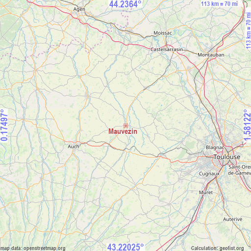
Mauvezin GPS coordinates[2]
43° 43' 49.728" North, 0° 52' 41.16" East
| Map corner | latitude | longitude |
|---|---|---|
| Upper-left | 44.2364°, | 0.17497° |
| Center: | 43.73048°, | 0.8781° |
| Lower-right: | 43.22025°, | 1.58122° |
| Map W x H: | 113×113 km | = 70.2×70.2mi |
| max Lat: | 51.07786° ⇑90% North |
| Mauvezin: | 43.73048° |
| min Lat: | ⇓10% South 41.3874° |
| min Long | Mauvezin | max Long |
| -5.08615° | 0.8781° | 9.52242° |
| W 30.1%⇐ | ⇒69.9% E |
Elevation
Elevation of Mauvezin is 160 m = 525 ft, and this is 33.7 m = 111 ft below average elevation for this country.
| Max E: |
2333 m = 7654 ft | 42.4% |
| Avg. | 193.7 m = 635 ft | |
| Mauvezin | 160 m = 525 ft | |
Min E: |
-1 m = -3 ft | 57.6% |
See also: France elevation on elevation.city.
Geographical zone
Mauvezin is located in North temperate zone (between Tropic of Cancer and the Arctic Circle). Distance of this Northern Tropic circle is 2256.5 km =1402.1 mi to South.| Distance of | km | miles | from Mauvezin |
|---|---|---|---|
| North Pole | 5144.7 | 3196.8 | to North |
| Arctic Circle | 2538.8 | 1577.5 | to North |
| Tropic Cancer | 2256.5 | 1402.1 | to South |
| Equator | 4862.4 | 3021.4 | to South |


Nearby cities:
15 places around Mauvezin: (largest is in red/bold)
• Aubiet
12 km =7.5 mi,  218°
218°
• Beaumont-de-Lomagne
19.1 km =11.9 mi,  27°
27°
• Cadours
13.9 km =8.6 mi,  90°
90°
• Cologne
8 km =5 mi,  96°
96°
• Escornebœuf
9.1 km =5.7 mi,  168°
168°
• Fleurance
21.7 km =13.5 mi,  307°
307°
• Gimont
11.6 km =7.2 mi,  180°
180°
• Le Castéra
22.1 km =13.7 mi,  106°
106°
• L’Isle-Jourdain
21 km =13 mi,  128°
128°
• Marignac
13 km =8.1 mi,  12°
12°
• Monferran-Savès
16.9 km =10.5 mi,  150°
150°
• Montestruc-sur-Gers
21.2 km =13.2 mi,  289°
289°
• Preignan
20.4 km =12.7 mi,  264°
264°
• Saint-Clar
19.8 km =12.3 mi,  333°
333°
• Touget
5.4 km =3.4 mi, 147°
Sources, notices
• [Note1] Compared only with cities in France existing in our database
• [Src1] Map data: © OpenStreetMap contributors (CC-BY-SA)
• [Src2] Other city data from geonames.org with taken over terms of usage.
• [Src3] Geographical zone / Annual Mean Temperature by Robert A. Rohde @ Wikipedia
