Saint-Bauzille-de-Putois geodata
Saint-Bauzille-de-Putois (Occitanie) is a populated place; located in France in Europe/Paris (GMT+2) time zone. With population of 1,283 people, there are 7117 cities with bigger population in this country. Compared to other cities in France, 88.1% of cities are located further ↑North; 66% of cities are located further ←West and 51.9% of cities have lower elevation than Saint-Bauzille-de-Putois. Note1
Administrative division(s):
- Level 1: Occitanie
- Level 2: Département de l'Hérault
- Level 3: Arrondissement de Lodève
- Level 4: Saint-Bauzille-de-Putois
Current local time in Saint-Bauzille-de-Putois:
01:49 PM, MondayDifference from your time zone: hours


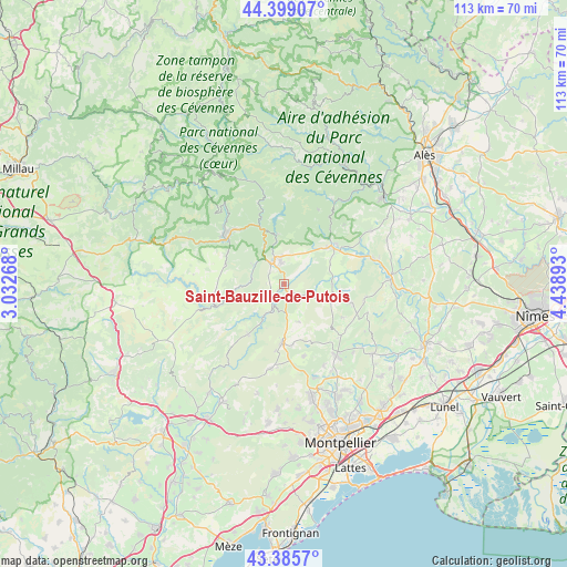
Saint-Bauzille-de-Putois GPS coordinates[2]
43° 53' 40.344" North, 3° 44' 8.88" East
| Map corner | latitude | longitude |
|---|---|---|
| Upper-left | 44.39907°, | 3.03268° |
| Center: | 43.89454°, | 3.7358° |
| Lower-right: | 43.3857°, | 4.43893° |
| Map W x H: | 112.7×112.7 km | = 70×70mi |
| max Lat: | 51.07786° ⇑88.1% North |
| Saint-Bauzille-de-Putois: | 43.89454° |
| min Lat: | ⇓11.9% South 41.3874° |
| min Long | Saint-Bauzille- | max Long |
| -5.08615° | 3.7358° | 9.52242° |
| W 66%⇐ | ⇒34% E |
Elevation
Elevation of Saint-Bauzille-de-Putois is 139 m = 456 ft, and this is 54.7 m = 179 ft below average elevation for this country.
| Max E: |
2333 m = 7654 ft | 48.1% |
| Avg. | 193.7 m = 635 ft | |
| Saint-Bauzille-de-Putois | 139 m = 456 ft | |
Min E: |
-1 m = -3 ft | 51.9% |
See also: France elevation on elevation.city.
Geographical zone
Saint-Bauzille-de-Putois is located in North temperate zone (between Tropic of Cancer and the Arctic Circle). Distance of this Northern Tropic circle is 2274.7 km =1413.4 mi to South.| Distance of | km | miles | from Saint-Bauzille-de-Putois |
|---|---|---|---|
| North Pole | 5126.4 | 3185.4 | to North |
| Arctic Circle | 2520.6 | 1566.2 | to North |
| Tropic Cancer | 2274.7 | 1413.4 | to South |
| Equator | 4880.6 | 3032.7 | to South |


Nearby cities:
15 places around Saint-Bauzille-de-Putois: (largest is in red/bold)
• Avèze
13.8 km =8.6 mi,  308°
308°
• Brissac
3.2 km =2 mi,  234°
234°
• Cazilhac
3.9 km =2.4 mi,  317°
317°
• Claret
14 km =8.7 mi,  104°
104°
• Corconne
16.5 km =10.3 mi, 98°
• Ganges
4.9 km =3 mi,  332°
332°
• Laroque
3.3 km =2.1 mi,  343°
343°
• Le Vigan
15.1 km =9.4 mi, 316°
• Molières-Cavaillac
15.6 km =9.7 mi, 305°
• Pompignan
9.6 km =6 mi,  90°
90°
• Saint-André-de-Majencoules
15.6 km =9.7 mi, 342°
• Saint-Hippolyte-du-Fort
12.3 km =7.6 mi,  51°
51°
• Saint-Martin-de-Londres
11.6 km =7.2 mi,  182°
182°
• Sumène
9.7 km =6 mi,  350°
350°
• Valflaunès
15.2 km =9.4 mi,  133°
133°
Sources, notices
• [Note1] Compared only with cities in France existing in our database
• [Src1] Map data: © OpenStreetMap contributors (CC-BY-SA)
• [Src2] Other city data from geonames.org with taken over terms of usage.
• [Src3] Geographical zone / Annual Mean Temperature by Robert A. Rohde @ Wikipedia
