Garnat-sur-Engièvre geodata
Garnat-sur-Engièvre (Auvergne-Rhône-Alpes) is a populated place; located in France in Europe/Paris (GMT+2) time zone. With population of 746 people, there are 11210 cities with bigger population in this country. Compared to other cities in France, 58.9% of cities are located further ↑North; 65.5% of cities are located further ←West and 67.6% of cities have lower elevation than Garnat-sur-Engièvre. Note1
Administrative division(s):
- Level 1: Auvergne-Rhône-Alpes
- Level 2: Département de l'Allier
- Level 3: Arrondissement de Moulins
- Level 4: Garnat-sur-Engièvre


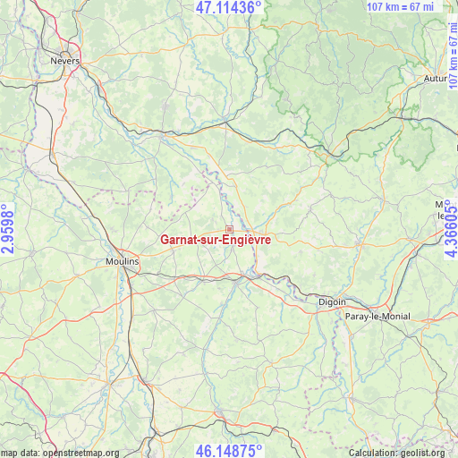
Garnat-sur-Engièvre GPS coordinates[2]
46° 38' 1.356" North, 3° 39' 46.548" East
| Map corner | latitude | longitude |
|---|---|---|
| Upper-left | 47.11436°, | 2.9598° |
| Center: | 46.63371°, | 3.66293° |
| Lower-right: | 46.14875°, | 4.36605° |
| Map W x H: | 107.4×107.4 km | = 66.7×66.7mi |
| max Lat: | 51.07786° ⇑58.9% North |
| Garnat-sur-Engièvre: | 46.63371° |
| min Lat: | ⇓41.1% South 41.3874° |
| min Long | Garnat-sur-Engi | max Long |
| -5.08615° | 3.66293° | 9.52242° |
| W 65.5%⇐ | ⇒34.5% E |
Elevation
Elevation of Garnat-sur-Engièvre is 207 m = 679 ft, and this is 13.3 m = 44 ft above average elevation for this country.
| Max E: |
2333 m = 7654 ft | 32.4% |
| Garnat-sur-Engièvre | 207 m 679 ft | |
| Avg. | 193.7 m = 635 ft | |
Min E: |
-1 m = -3 ft | 67.6% |
See also: France elevation on elevation.city.
Geographical zone
Garnat-sur-Engièvre is located in North temperate zone (between Tropic of Cancer and the Arctic Circle). Distance of this North polar circle is 2216 km =1377 mi to North.| Distance of | km | miles | from Garnat-sur-Engièvre |
|---|---|---|---|
| North Pole | 4821.9 | 2996.2 | to North |
| Arctic Circle | 2216 | 1377 | to North |
| Tropic Cancer | 2579.3 | 1602.7 | to South |
| Equator | 5185.2 | 3221.9 | to South |


Nearby cities:
15 places around Garnat-sur-Engièvre: (largest is in red/bold)
• Beaulon
3.7 km =2.3 mi,  167°
167°
• Bourbon-Lancy
8.2 km =5.1 mi,  98°
98°
• Chalmoux
14.6 km =9.1 mi,  105°
105°
• Charrin
17.8 km =11.1 mi,  343°
343°
• Chevagnes
8.9 km =5.5 mi,  253°
253°
• Cossaye
18.6 km =11.6 mi,  313°
313°
• Cronat
10 km =6.2 mi,  10°
10°
• Diou
12.7 km =7.9 mi,  150°
150°
• Dompierre-sur-Besbre
12.5 km =7.8 mi, 173°
• Gilly-sur-Loire
13.9 km =8.6 mi,  139°
139°
• Lucenay-lès-Aix
15.7 km =9.8 mi,  299°
299°
• Lusigny
14.1 km =8.8 mi, 248°
• Montbeugny
17.7 km =11 mi,  228°
228°
• Pierrefitte-sur-Loire
18.4 km =11.4 mi, 140°
• Thiel-sur-Acolin
13.7 km =8.5 mi,  206°
206°
Sources, notices
• [Note1] Compared only with cities in France existing in our database
• [Src1] Map data: © OpenStreetMap contributors (CC-BY-SA)
• [Src2] Other city data from geonames.org with taken over terms of usage.
• [Src3] Geographical zone / Annual Mean Temperature by Robert A. Rohde @ Wikipedia
