Courteuil geodata
Courteuil (Hauts-de-France) is a populated place; located in France in Europe/Paris (GMT+2) time zone. With population of 642 people, there are 12644 cities with bigger population in this country. Compared to other cities in France, 84.3% of cities are located further ↓South; 51.1% of cities are located further ←West and 78.6% of cities have higher elevation than Courteuil. Note1
Administrative division(s):
- Level 1: Hauts-de-France
- Level 2: Département de l'Oise
- Level 3: Arrondissement de Senlis
- Level 4: Courteuil


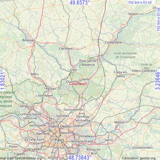
Courteuil GPS coordinates[2]
49° 12' 0" North, 2° 31' 59.988" East
| Map corner | latitude | longitude |
|---|---|---|
| Upper-left | 49.6573°, | 1.83021° |
| Center: | 49.2°, | 2.53333° |
| Lower-right: | 48.73843°, | 3.23646° |
| Map W x H: | 102.2×102.2 km | = 63.5×63.5mi |
| max Lat: | 51.07786° ⇑15.7% North |
| Courteuil: | 49.2° |
| min Lat: | ⇓84.3% South 41.3874° |
| min Long | Courteuil | max Long |
| -5.08615° | 2.53333° | 9.52242° |
| W 51.1%⇐ | ⇒48.9% E |
Elevation
Elevation of Courteuil is 58 m = 190 ft, and this is 135.7 m = 445 ft below average elevation for this country.
| Max E: |
2333 m = 7654 ft | 78.6% |
| Avg. | 193.7 m = 635 ft | |
| Courteuil | 58 m = 190 ft | |
Min E: |
-1 m = -3 ft | 21.4% |
See also: France elevation on elevation.city.
Geographical zone
Courteuil is located in North temperate zone (between Tropic of Cancer and the Arctic Circle). Distance of this North polar circle is 1930.6 km =1199.6 mi to North.| Distance of | km | miles | from Courteuil |
|---|---|---|---|
| North Pole | 4536.5 | 2818.8 | to North |
| Arctic Circle | 1930.6 | 1199.6 | to North |
| Tropic Cancer | 2864.6 | 1780 | to South |
| Equator | 5470.5 | 3399.2 | to South |


Nearby cities:
15 places around Courteuil: (largest is in red/bold)
• Apremont
3.2 km =2 mi,  325°
325°
• Aumont-en-Halatte
3.9 km =2.4 mi,  18°
18°
• Avilly-Saint-Léonard
0.9 km =0.6 mi,  135°
135°
• Chamant
6.1 km =3.8 mi,  68°
68°
• Chantilly
4.6 km =2.9 mi,  262°
262°
• Coye-la-Forêt
7.9 km =4.9 mi,  215°
215°
• Creil
7.2 km =4.5 mi, 330°
• Fleurines
7.5 km =4.7 mi,  29°
29°
• Lamorlaye
7.5 km =4.7 mi,  236°
236°
• Orry-la-Ville
7.6 km =4.7 mi,  192°
192°
• Pontarmé
5.3 km =3.3 mi,  166°
166°
• Saint-Maximin
6.3 km =3.9 mi,  292°
292°
• Senlis
4 km =2.5 mi,  78°
78°
• Thiers-sur-Thève
5.9 km =3.7 mi,  152°
152°
• Vineuil-Saint-Firmin
2.7 km =1.7 mi,  270°
270°
Sources, notices
• [Note1] Compared only with cities in France existing in our database
• [Src1] Map data: © OpenStreetMap contributors (CC-BY-SA)
• [Src2] Other city data from geonames.org with taken over terms of usage.
• [Src3] Geographical zone / Annual Mean Temperature by Robert A. Rohde @ Wikipedia
