Gannat geodata
Gannat (Auvergne-Rhône-Alpes) is a populated place; located in France in Europe/Paris (GMT+2) time zone. With population of 6,096 people, there are 1622 cities with bigger population in this country. Compared to other cities in France, 65.1% of cities are located further ↑North; 60.6% of cities are located further ←West and 84.7% of cities have lower elevation than Gannat. Note1
Administrative division(s):
- Level 1: Auvergne-Rhône-Alpes
- Level 2: Département de l'Allier
- Level 3: Arrondissement de Vichy
- Level 4: Gannat


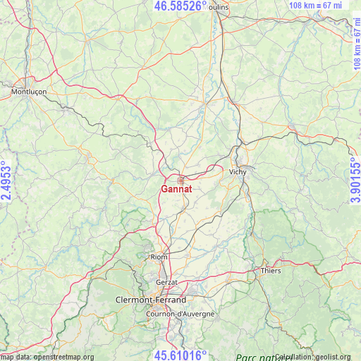
Gannat GPS coordinates[2]
46° 5' 59.532" North, 3° 11' 54.312" East
| Map corner | latitude | longitude |
|---|---|---|
| Upper-left | 46.58526°, | 2.4953° |
| Center: | 46.09987°, | 3.19842° |
| Lower-right: | 45.61016°, | 3.90155° |
| Map W x H: | 108.4×108.4 km | = 67.4×67.4mi |
| max Lat: | 51.07786° ⇑65.1% North |
| Gannat: | 46.09987° |
| min Lat: | ⇓34.9% South 41.3874° |
| min Long | Gannat | max Long |
| -5.08615° | 3.19842° | 9.52242° |
| W 60.6%⇐ | ⇒39.4% E |
Elevation
Elevation of Gannat is 342 m = 1122 ft, and this is 148.3 m = 487 ft above average elevation for this country.
| Max E: |
2333 m = 7654 ft | 15.3% |
| Gannat | 342 m 1122 ft | |
| Avg. | 193.7 m = 635 ft | |
Min E: |
-1 m = -3 ft | 84.7% |
See also: France elevation on elevation.city.
Geographical zone
Gannat is located in North temperate zone (between Tropic of Cancer and the Arctic Circle). Distance of this North polar circle is 2275.3 km =1413.8 mi to North.| Distance of | km | miles | from Gannat |
|---|---|---|---|
| North Pole | 4881.2 | 3033 | to North |
| Arctic Circle | 2275.3 | 1413.8 | to North |
| Tropic Cancer | 2519.9 | 1565.8 | to South |
| Equator | 5125.8 | 3185 | to South |


Nearby cities:
15 places around Gannat: (largest is in red/bold)
• Aigueperse
8.6 km =5.3 mi,  178°
178°
• Artonne
11.5 km =7.1 mi,  201°
201°
• Bellenaves
14.4 km =8.9 mi,  320°
320°
• Biozat
6.3 km =3.9 mi,  114°
114°
• Broût-Vernet
11.3 km =7 mi,  30°
30°
• Brugheas
13.3 km =8.3 mi,  101°
101°
• Cognat-Lyonne
8.7 km =5.4 mi,  83°
83°
• Effiat
8 km =5 mi,  146°
146°
• Escurolles
7.1 km =4.4 mi,  46°
46°
• Espinasse-Vozelle
10.1 km =6.3 mi,  73°
73°
• Saint-Bonnet-de-Rochefort
6.9 km =4.3 mi, 318°
• Serbannes
12.4 km =7.7 mi,  90°
90°
• Vendat
13.9 km =8.6 mi,  59°
59°
• Ébreuil
8.8 km =5.5 mi,  281°
281°
• Étroussat
13.3 km =8.3 mi,  7°
7°
Sources, notices
• [Note1] Compared only with cities in France existing in our database
• [Src1] Map data: © OpenStreetMap contributors (CC-BY-SA)
• [Src2] Other city data from geonames.org with taken over terms of usage.
• [Src3] Geographical zone / Annual Mean Temperature by Robert A. Rohde @ Wikipedia
