La Selve geodata
La Selve (Occitanie) is a populated place; located in France in Europe/Paris (GMT+2) time zone. With population of 735 people, there are 11351 cities with bigger population in this country. Compared to other cities in France, 86.1% of cities are located further ↑North; 51.2% of cities are located further ←West and 94.6% of cities have lower elevation than La Selve. Note1
Administrative division(s):
- Level 1: Occitanie
- Level 2: Département de l'Aveyron
- Level 3: Arrondissement de Millau
- Level 4: La Selve


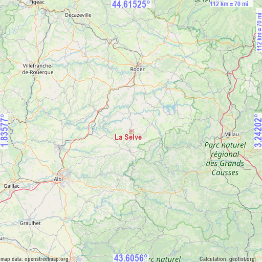
La Selve GPS coordinates[2]
44° 6' 45.288" North, 2° 32' 20.004" East
| Map corner | latitude | longitude |
|---|---|---|
| Upper-left | 44.61525°, | 1.83577° |
| Center: | 44.11258°, | 2.53889° |
| Lower-right: | 43.6056°, | 3.24202° |
| Map W x H: | 112.3×112.3 km | = 69.8×69.8mi |
| max Lat: | 51.07786° ⇑86.1% North |
| La Selve: | 44.11258° |
| min Lat: | ⇓13.9% South 41.3874° |
| min Long | La Selve | max Long |
| -5.08615° | 2.53889° | 9.52242° |
| W 51.2%⇐ | ⇒48.8% E |
Elevation
Elevation of La Selve is 565 m = 1854 ft, and this is 371.3 m = 1218 ft above average elevation for this country.
| Max E: |
2333 m = 7654 ft | 5.4% |
| La Selve | 565 m 1854 ft | |
| Avg. | 193.7 m = 635 ft | |
Min E: |
-1 m = -3 ft | 94.6% |
See also: France elevation on elevation.city.
Geographical zone
La Selve is located in North temperate zone (between Tropic of Cancer and the Arctic Circle). Distance of this Northern Tropic circle is 2298.9 km =1428.5 mi to South.| Distance of | km | miles | from La Selve |
|---|---|---|---|
| North Pole | 5102.2 | 3170.4 | to North |
| Arctic Circle | 2496.3 | 1551.1 | to North |
| Tropic Cancer | 2298.9 | 1428.5 | to South |
| Equator | 4904.9 | 3047.8 | to South |


Nearby cities:
15 places around La Selve: (largest is in red/bold)
• Arvieu
13.1 km =8.1 mi,  47°
47°
• Broquiès
17.4 km =10.8 mi,  133°
133°
• Calmont
15.3 km =9.5 mi,  351°
351°
• Camjac
14.8 km =9.2 mi,  300°
300°
• Cassagnes-Bégonhès
6.3 km =3.9 mi, 354°
• Centrès
11.8 km =7.3 mi, 299°
• Durenque
6.4 km =4 mi,  93°
93°
• Lédergues
8.2 km =5.1 mi,  251°
251°
• Manhac
16.7 km =10.4 mi,  340°
340°
• Réquista
8.8 km =5.5 mi,  181°
181°
• Salmiech
8.2 km =5.1 mi,  19°
19°
• Tanus
17.7 km =11 mi,  266°
266°
• Trémouilles
16.9 km =10.5 mi,  29°
29°
• Valence-d’Albigeois
14.9 km =9.3 mi,  225°
225°
• Villefranche-de-Panat
13.6 km =8.5 mi,  101°
101°
Sources, notices
• [Note1] Compared only with cities in France existing in our database
• [Src1] Map data: © OpenStreetMap contributors (CC-BY-SA)
• [Src2] Other city data from geonames.org with taken over terms of usage.
• [Src3] Geographical zone / Annual Mean Temperature by Robert A. Rohde @ Wikipedia
