Cassagnes-Bégonhès geodata
Cassagnes-Bégonhès (Occitanie) is a populated place; located in France in Europe/Paris (GMT+2) time zone. With population of 1,032 people, there are 8599 cities with bigger population in this country. Compared to other cities in France, 85.7% of cities are located further ↑North; 51.1% of cities are located further ←West and 93.9% of cities have lower elevation than Cassagnes-Bégonhès. Note1
Administrative division(s):
- Level 1: Occitanie
- Level 2: Département de l'Aveyron
- Level 3: Arrondissement de Villefranche-de-Rouergue
- Level 4: Cassagnes-Bégonhès


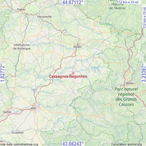
Cassagnes-Bégonhès GPS coordinates[2]
44° 10' 8.148" North, 2° 31' 51.024" East
| Map corner | latitude | longitude |
|---|---|---|
| Upper-left | 44.67112°, | 1.82772° |
| Center: | 44.16893°, | 2.53084° |
| Lower-right: | 43.66243°, | 3.23397° |
| Map W x H: | 112.2×112.2 km | = 69.7×69.7mi |
| max Lat: | 51.07786° ⇑85.7% North |
| Cassagnes-Bégonhès: | 44.16893° |
| min Lat: | ⇓14.3% South 41.3874° |
| min Long | Cassagnes-Bégo | max Long |
| -5.08615° | 2.53084° | 9.52242° |
| W 51.1%⇐ | ⇒48.9% E |
Elevation
Elevation of Cassagnes-Bégonhès is 540 m = 1772 ft, and this is 346.3 m = 1136 ft above average elevation for this country.
| Max E: |
2333 m = 7654 ft | 6.1% |
| Cassagnes-Bégonhès | 540 m 1772 ft | |
| Avg. | 193.7 m = 635 ft | |
Min E: |
-1 m = -3 ft | 93.9% |
See also: France elevation on elevation.city.
Geographical zone
Cassagnes-Bégonhès is located in North temperate zone (between Tropic of Cancer and the Arctic Circle). Distance of this Northern Tropic circle is 2305.2 km =1432.4 mi to South.| Distance of | km | miles | from Cassagnes-Bégonhès |
|---|---|---|---|
| North Pole | 5095.9 | 3166.4 | to North |
| Arctic Circle | 2490 | 1547.2 | to North |
| Tropic Cancer | 2305.2 | 1432.4 | to South |
| Equator | 4911.1 | 3051.6 | to South |


Nearby cities:
15 places around Cassagnes-Bégonhès: (largest is in red/bold)
• Arvieu
10.7 km =6.6 mi,  76°
76°
• Baraqueville
14.3 km =8.9 mi,  326°
326°
• Calmont
9 km =5.6 mi,  350°
350°
• Camjac
12.2 km =7.6 mi,  275°
275°
• Centrès
9.7 km =6 mi,  266°
266°
• Durenque
9.6 km =6 mi,  133°
133°
• Flavin
14.6 km =9.1 mi,  23°
23°
• La Selve
6.3 km =3.9 mi,  174°
174°
• Lédergues
11.4 km =7.1 mi,  218°
218°
• Manhac
10.7 km =6.6 mi, 332°
• Naucelle
15.3 km =9.5 mi, 282°
• Quins
14.4 km =8.9 mi,  299°
299°
• Réquista
15.1 km =9.4 mi,  178°
178°
• Salmiech
3.7 km =2.3 mi,  67°
67°
• Trémouilles
12.3 km =7.6 mi,  47°
47°
Sources, notices
• [Note1] Compared only with cities in France existing in our database
• [Src1] Map data: © OpenStreetMap contributors (CC-BY-SA)
• [Src2] Other city data from geonames.org with taken over terms of usage.
• [Src3] Geographical zone / Annual Mean Temperature by Robert A. Rohde @ Wikipedia
