Salmiech geodata
Salmiech (Occitanie) is a populated place; located in France in Europe/Paris (GMT+2) time zone. With population of 765 people, there are 11005 cities with bigger population in this country. Compared to other cities in France, 85.7% of cities are located further ↑North; 51.8% of cities are located further ←West and 95.7% of cities have lower elevation than Salmiech. Note1
Administrative division(s):
- Level 1: Occitanie
- Level 2: Département de l'Aveyron
- Level 3: Arrondissement de Millau
- Level 4: Salmiech


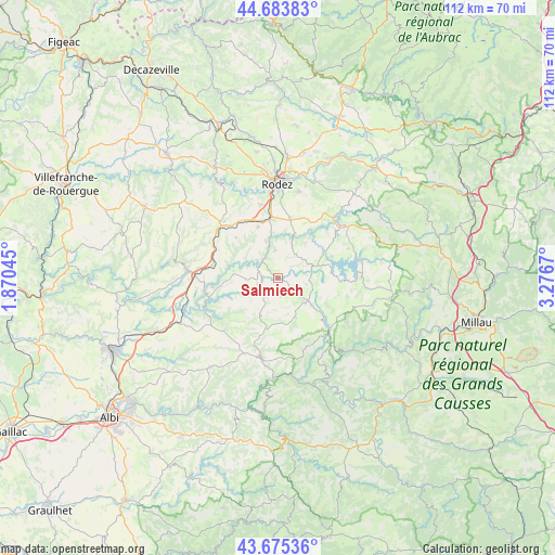
Salmiech GPS coordinates[2]
44° 10' 54.3" North, 2° 34' 24.888" East
| Map corner | latitude | longitude |
|---|---|---|
| Upper-left | 44.68383°, | 1.87045° |
| Center: | 44.18175°, | 2.57358° |
| Lower-right: | 43.67536°, | 3.2767° |
| Map W x H: | 112.1×112.1 km | = 69.7×69.7mi |
| max Lat: | 51.07786° ⇑85.7% North |
| Salmiech: | 44.18175° |
| min Lat: | ⇓14.3% South 41.3874° |
| min Long | Salmiech | max Long |
| -5.08615° | 2.57358° | 9.52242° |
| W 51.8%⇐ | ⇒48.2% E |
Elevation
Elevation of Salmiech is 623 m = 2044 ft, and this is 429.3 m = 1408 ft above average elevation for this country.
| Max E: |
2333 m = 7654 ft | 4.3% |
| Salmiech | 623 m 2044 ft | |
| Avg. | 193.7 m = 635 ft | |
Min E: |
-1 m = -3 ft | 95.7% |
See also: France elevation on elevation.city.
Geographical zone
Salmiech is located in North temperate zone (between Tropic of Cancer and the Arctic Circle). Distance of this Northern Tropic circle is 2306.6 km =1433.3 mi to South.| Distance of | km | miles | from Salmiech |
|---|---|---|---|
| North Pole | 5094.5 | 3165.6 | to North |
| Arctic Circle | 2488.6 | 1546.3 | to North |
| Tropic Cancer | 2306.6 | 1433.3 | to South |
| Equator | 4912.6 | 3052.5 | to South |


Nearby cities:
15 places around Salmiech: (largest is in red/bold)
• Arvieu
7.1 km =4.4 mi,  80°
80°
• Baraqueville
15.4 km =9.6 mi,  313°
313°
• Calmont
8.9 km =5.5 mi,  326°
326°
• Camjac
15.5 km =9.6 mi,  269°
269°
• Cassagnes-Bégonhès
3.7 km =2.3 mi,  247°
247°
• Centrès
13.2 km =8.2 mi,  261°
261°
• Durenque
8.8 km =5.5 mi,  155°
155°
• Flavin
12.2 km =7.6 mi,  11°
11°
• La Selve
8.2 km =5.1 mi,  199°
199°
• Luc-la-Primaube
15.1 km =9.4 mi,  348°
348°
• Lédergues
14.7 km =9.1 mi,  225°
225°
• Manhac
11.6 km =7.2 mi, 314°
• Pont-de-Salars
16.5 km =10.3 mi,  48°
48°
• Trémouilles
9 km =5.6 mi,  38°
38°
• Villefranche-de-Panat
14.7 km =9.1 mi,  134°
134°
Sources, notices
• [Note1] Compared only with cities in France existing in our database
• [Src1] Map data: © OpenStreetMap contributors (CC-BY-SA)
• [Src2] Other city data from geonames.org with taken over terms of usage.
• [Src3] Geographical zone / Annual Mean Temperature by Robert A. Rohde @ Wikipedia
