Burlats geodata
Burlats (Occitanie) is a populated place; located in France in Europe/Paris (GMT+2) time zone. With population of 1,938 people, there are 4941 cities with bigger population in this country. Compared to other cities in France, 91.4% of cities are located further ↑North; 52.4% of cities are located further →East and 65.8% of cities have lower elevation than Burlats. Note1
Administrative division(s):
- Level 1: Occitanie
- Level 2: Tarn
- Level 3: Arrondissement de Castres
- Level 4: Burlats


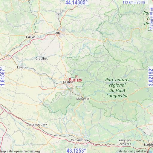
Burlats GPS coordinates[2]
43° 38' 10.788" North, 2° 19' 7.644" East
| Map corner | latitude | longitude |
|---|---|---|
| Upper-left | 44.14305°, | 1.61567° |
| Center: | 43.63633°, | 2.31879° |
| Lower-right: | 43.1253°, | 3.02192° |
| Map W x H: | 113.2×113.2 km | = 70.3×70.3mi |
| max Lat: | 51.07786° ⇑91.4% North |
| Burlats: | 43.63633° |
| min Lat: | ⇓8.6% South 41.3874° |
| min Long | Burlats | max Long |
| -5.08615° | 2.31879° | 9.52242° |
| W 47.6%⇐ | ⇒52.4% E |
Elevation
Elevation of Burlats is 198 m = 650 ft, and this is 4.3 m = 14 ft above average elevation for this country.
| Max E: |
2333 m = 7654 ft | 34.2% |
| Burlats | 198 m 650 ft | |
| Avg. | 193.7 m = 635 ft | |
Min E: |
-1 m = -3 ft | 65.8% |
See also: France elevation on elevation.city.
Geographical zone
Burlats is located in North temperate zone (between Tropic of Cancer and the Arctic Circle). Distance of this Northern Tropic circle is 2246 km =1395.6 mi to South.| Distance of | km | miles | from Burlats |
|---|---|---|---|
| North Pole | 5155.2 | 3203.3 | to North |
| Arctic Circle | 2549.3 | 1584.1 | to North |
| Tropic Cancer | 2246 | 1395.6 | to South |
| Equator | 4851.9 | 3014.8 | to South |


Nearby cities:
15 places around Burlats: (largest is in red/bold)
• Castres
7.2 km =4.5 mi,  241°
241°
• Labruguière
11.7 km =7.3 mi,  202°
202°
• Lacrouzette
3.6 km =2.2 mi,  41°
41°
• Lagarrigue
7.3 km =4.5 mi,  206°
206°
• Le Bez
13.1 km =8.1 mi,  105°
105°
• Montredon-Labessonnié
9 km =5.6 mi,  2°
2°
• Navès
10.9 km =6.8 mi,  223°
223°
• Noailhac
7.6 km =4.7 mi,  158°
158°
• Payrin-Augmontel
10.6 km =6.6 mi, 164°
• Roquecourbe
3.8 km =2.4 mi,  326°
326°
• Saint-Affrique-les-Montagnes
14.2 km =8.8 mi, 219°
• Saint-Salvy-de-la-Balme
7 km =4.3 mi, 113°
• Saïx
12.4 km =7.7 mi, 241°
• Vabre
10.5 km =6.5 mi,  54°
54°
• Valdurenque
7.5 km =4.7 mi,  187°
187°
Sources, notices
• [Note1] Compared only with cities in France existing in our database
• [Src1] Map data: © OpenStreetMap contributors (CC-BY-SA)
• [Src2] Other city data from geonames.org with taken over terms of usage.
• [Src3] Geographical zone / Annual Mean Temperature by Robert A. Rohde @ Wikipedia
