Saint-Pol-sur-Ternoise geodata
Saint-Pol-sur-Ternoise (Hauts-de-France) is a populated place; located in France in Europe/Paris (GMT+2) time zone. With population of 5,603 people, there are 1768 cities with bigger population in this country. Compared to other cities in France, 96.3% of cities are located further ↓South; 52.1% of cities are located further →East and 64.4% of cities have higher elevation than Saint-Pol-sur-Ternoise. Note1
Administrative division(s):
- Level 1: Hauts-de-France
- Level 2: Pas-de-Calais
- Level 3: Arras
- Level 4: Saint-Pol-sur-Ternoise


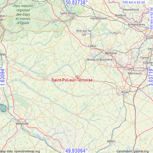
Saint-Pol-sur-Ternoise GPS coordinates[2]
50° 22' 52.068" North, 2° 20' 2.652" East
| Map corner | latitude | longitude |
|---|---|---|
| Upper-left | 50.82738°, | 1.63094° |
| Center: | 50.38113°, | 2.33407° |
| Lower-right: | 49.93064°, | 3.03719° |
| Map W x H: | 99.7×99.7 km | = 62×62mi |
| max Lat: | 51.07786° ⇑3.7% North |
| Saint-Pol-sur-Ternoise: | 50.38113° |
| min Lat: | ⇓96.3% South 41.3874° |
| min Long | Saint-Pol-sur-T | max Long |
| -5.08615° | 2.33407° | 9.52242° |
| W 47.9%⇐ | ⇒52.1% E |
Elevation
Elevation of Saint-Pol-sur-Ternoise is 91 m = 299 ft, and this is 102.7 m = 337 ft below average elevation for this country.
| Max E: |
2333 m = 7654 ft | 64.4% |
| Avg. | 193.7 m = 635 ft | |
| Saint-Pol-sur-Ternoise | 91 m = 299 ft | |
Min E: |
-1 m = -3 ft | 35.6% |
See also: France elevation on elevation.city.
Geographical zone
Saint-Pol-sur-Ternoise is located in North temperate zone (between Tropic of Cancer and the Arctic Circle). Distance of this North polar circle is 1799.3 km =1118 mi to North.| Distance of | km | miles | from Saint-Pol-sur-Ternoise |
|---|---|---|---|
| North Pole | 4405.2 | 2737.3 | to North |
| Arctic Circle | 1799.3 | 1118 | to North |
| Tropic Cancer | 2995.9 | 1861.6 | to South |
| Equator | 5601.9 | 3480.9 | to South |


Nearby cities:
15 places around Saint-Pol-sur-Ternoise: (largest is in red/bold)
• Anvin
9.2 km =5.7 mi,  321°
321°
• Blangy-sur-Ternoise
12.5 km =7.8 mi,  290°
290°
• Boubers-sur-Canche
12.3 km =7.6 mi,  214°
214°
• Bours
9.7 km =6 mi,  33°
33°
• Diéval
10.2 km =6.3 mi,  53°
53°
• Frévent
12.1 km =7.5 mi,  195°
195°
• Gauchin-Verloingt
2.3 km =1.4 mi, 316°
• Heuchin
11.4 km =7.1 mi,  336°
336°
• La Comté
12.2 km =7.6 mi,  66°
66°
• Magnicourt-en-Comte
11.9 km =7.4 mi,  79°
79°
• Ourton
13.4 km =8.3 mi, 51°
• Pernes
12.8 km =8 mi, 25°
• Roëllecourt
4 km =2.5 mi,  111°
111°
• Tincques
11.5 km =7.1 mi,  102°
102°
• Valhuon
6.6 km =4.1 mi, 28°
Sources, notices
• [Note1] Compared only with cities in France existing in our database
• [Src1] Map data: © OpenStreetMap contributors (CC-BY-SA)
• [Src2] Other city data from geonames.org with taken over terms of usage.
• [Src3] Geographical zone / Annual Mean Temperature by Robert A. Rohde @ Wikipedia
