Le Mesnil-Esnard geodata
Le Mesnil-Esnard (Normandy) is a populated place; located in France in Europe/Paris (GMT+2) time zone. With population of 6,380 people, there are 1550 cities with bigger population in this country. Compared to other cities in France, 88.1% of cities are located further ↓South; 67.4% of cities are located further →East and 55.9% of cities have lower elevation than Le Mesnil-Esnard. Note1
Administrative division(s):
- Level 1: Normandy
- Level 2: Seine-Maritime
- Level 3: Arrondissement de Rouen
- Level 4: Le Mesnil-Esnard


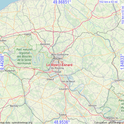
Le Mesnil-Esnard GPS coordinates[2]
49° 24' 47.484" North, 1° 8' 42.756" East
| Map corner | latitude | longitude |
|---|---|---|
| Upper-left | 49.86851°, | 0.44208° |
| Center: | 49.41319°, | 1.14521° |
| Lower-right: | 48.9536°, | 1.84833° |
| Map W x H: | 101.7×101.7 km | = 63.2×63.2mi |
| max Lat: | 51.07786° ⇑11.9% North |
| Le Mesnil-Esnard: | 49.41319° |
| min Lat: | ⇓88.1% South 41.3874° |
| min Long | Le Mesnil-Esnar | max Long |
| -5.08615° | 1.14521° | 9.52242° |
| W 32.6%⇐ | ⇒67.4% E |
Elevation
Elevation of Le Mesnil-Esnard is 153 m = 502 ft, and this is 40.7 m = 134 ft below average elevation for this country.
| Max E: |
2333 m = 7654 ft | 44.1% |
| Avg. | 193.7 m = 635 ft | |
| Le Mesnil-Esnard | 153 m = 502 ft | |
Min E: |
-1 m = -3 ft | 55.9% |
See also: France elevation on elevation.city.
Geographical zone
Le Mesnil-Esnard is located in North temperate zone (between Tropic of Cancer and the Arctic Circle). Distance of this North polar circle is 1906.9 km =1184.9 mi to North.| Distance of | km | miles | from Le Mesnil-Esnard |
|---|---|---|---|
| North Pole | 4512.8 | 2804.1 | to North |
| Arctic Circle | 1906.9 | 1184.9 | to North |
| Tropic Cancer | 2888.3 | 1794.7 | to South |
| Equator | 5494.2 | 3413.9 | to South |


Nearby cities:
15 places around Le Mesnil-Esnard: (largest is in red/bold)
• Amfreville-la-Mi-Voie
0.8 km =0.5 mi,  216°
216°
• Belbeuf
2.8 km =1.7 mi,  184°
184°
• Bihorel
4.9 km =3 mi,  340°
340°
• Bois-Guillaume
5.5 km =3.4 mi, 342°
• Boos
5 km =3.1 mi,  123°
123°
• Darnétal
3.6 km =2.2 mi,  7°
7°
• Le Petit-Quevilly
6.1 km =3.8 mi,  270°
270°
• Rouen
4.7 km =2.9 mi,  315°
315°
• Saint-Aubin-Celloville
5.6 km =3.5 mi,  169°
169°
• Saint-Aubin-Épinay
1.6 km =1 mi,  76°
76°
• Saint-Jacques-sur-Darnétal
5.2 km =3.2 mi,  54°
54°
• Saint-Léger-du-Bourg-Denis
2.4 km =1.5 mi,  22°
22°
• Saint-Martin-du-Vivier
6.1 km =3.8 mi, 14°
• Saint-Étienne-du-Rouvray
4.9 km =3 mi, 216°
• Sotteville-lès-Rouen
4 km =2.5 mi,  264°
264°
Sources, notices
• [Note1] Compared only with cities in France existing in our database
• [Src1] Map data: © OpenStreetMap contributors (CC-BY-SA)
• [Src2] Other city data from geonames.org with taken over terms of usage.
• [Src3] Geographical zone / Annual Mean Temperature by Robert A. Rohde @ Wikipedia
