Rouen geodata
Rouen (Normandy) is a seat of a first-order administrative division; located in France in Europe/Paris (GMT+2) time zone. With population of 112,787 people, there are 32 cities with bigger population in this country. Compared to other cities in France, 88.5% of cities are located further ↓South; 67.9% of cities are located further →East and 93.6% of cities have higher elevation than Rouen. Note1
Administrative division(s):
- Level 1: Normandy
- Level 2: Seine-Maritime
- Level 3: Arrondissement de Rouen
- Level 4: Rouen


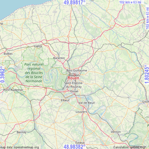
Rouen GPS coordinates[2]
49° 26' 35.268" North, 1° 5' 57.552" East
| Map corner | latitude | longitude |
|---|---|---|
| Upper-left | 49.89817°, | 0.3962° |
| Center: | 49.44313°, | 1.09932° |
| Lower-right: | 48.98382°, | 1.80245° |
| Map W x H: | 101.7×101.7 km | = 63.2×63.2mi |
| max Lat: | 51.07786° ⇑11.5% North |
| Rouen: | 49.44313° |
| min Lat: | ⇓88.5% South 41.3874° |
| min Long | Rouen | max Long |
| -5.08615° | 1.09932° | 9.52242° |
| W 32.1%⇐ | ⇒67.9% E |
Elevation
Elevation of Rouen is 21 m = 69 ft, and this is 172.7 m = 567 ft below average elevation for this country.
| Max E: |
2333 m = 7654 ft | 93.6% |
| Avg. | 193.7 m = 635 ft | |
| Rouen | 21 m = 69 ft | |
Min E: |
-1 m = -3 ft | 6.4% |
See also: Rouen elevation on elevation.city.
Geographical zone
Rouen is located in North temperate zone (between Tropic of Cancer and the Arctic Circle). Distance of this North polar circle is 1903.6 km =1182.8 mi to North.| Distance of | km | miles | from Rouen |
|---|---|---|---|
| North Pole | 4509.5 | 2802.1 | to North |
| Arctic Circle | 1903.6 | 1182.8 | to North |
| Tropic Cancer | 2891.6 | 1796.8 | to South |
| Equator | 5497.6 | 3416 | to South |


Nearby cities:
15 places around Rouen: (largest is in red/bold)
• Amfreville-la-Mi-Voie
4.9 km =3 mi,  144°
144°
• Bihorel
2.1 km =1.3 mi,  52°
52°
• Bois-Guillaume
2.5 km =1.6 mi,  41°
41°
• Canteleu
5.4 km =3.4 mi,  267°
267°
• Darnétal
3.8 km =2.4 mi,  86°
86°
• Déville-lès-Rouen
4.5 km =2.8 mi,  310°
310°
• Le Grand-Quevilly
6.1 km =3.8 mi,  219°
219°
• Le Mesnil-Esnard
4.7 km =2.9 mi, 135°
• Le Petit-Quevilly
4.3 km =2.7 mi, 219°
• Mont-Saint-Aignan
2.3 km =1.4 mi,  349°
349°
• Notre-Dame-de-Bondeville
5.7 km =3.5 mi,  321°
321°
• Saint-Aubin-Épinay
5.7 km =3.5 mi,  121°
121°
• Saint-Léger-du-Bourg-Denis
4.4 km =2.7 mi,  104°
104°
• Saint-Martin-du-Vivier
5.5 km =3.4 mi,  61°
61°
• Sotteville-lès-Rouen
3.8 km =2.4 mi,  190°
190°
Sources, notices
• [Note1] Compared only with cities in France existing in our database
• [Src1] Map data: © OpenStreetMap contributors (CC-BY-SA)
• [Src2] Other city data from geonames.org with taken over terms of usage.
• [Src3] Geographical zone / Annual Mean Temperature by Robert A. Rohde @ Wikipedia
