Bertholène geodata
Bertholène (Occitanie) is a populated place; located in France in Europe/Paris (GMT+2) time zone. With population of 967 people, there are 9081 cities with bigger population in this country. Compared to other cities in France, 84.3% of cities are located further ↑North; 54.6% of cities are located further ←West and 95.3% of cities have lower elevation than Bertholène. Note1
Administrative division(s):
- Level 1: Occitanie
- Level 2: Département de l'Aveyron
- Level 3: Arrondissement de Rodez
- Level 4: Bertholène


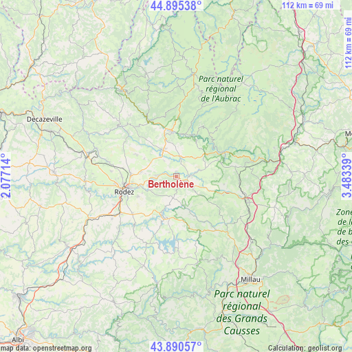
Bertholène GPS coordinates[2]
44° 23' 42.468" North, 2° 46' 48.936" East
| Map corner | latitude | longitude |
|---|---|---|
| Upper-left | 44.89538°, | 2.07714° |
| Center: | 44.39513°, | 2.78026° |
| Lower-right: | 43.89057°, | 3.48339° |
| Map W x H: | 111.7×111.7 km | = 69.4×69.4mi |
| max Lat: | 51.07786° ⇑84.3% North |
| Bertholène: | 44.39513° |
| min Lat: | ⇓15.7% South 41.3874° |
| min Long | Bertholène | max Long |
| -5.08615° | 2.78026° | 9.52242° |
| W 54.6%⇐ | ⇒45.4% E |
Elevation
Elevation of Bertholène is 602 m = 1975 ft, and this is 408.3 m = 1340 ft above average elevation for this country.
| Max E: |
2333 m = 7654 ft | 4.7% |
| Bertholène | 602 m 1975 ft | |
| Avg. | 193.7 m = 635 ft | |
Min E: |
-1 m = -3 ft | 95.3% |
See also: France elevation on elevation.city.
Geographical zone
Bertholène is located in North temperate zone (between Tropic of Cancer and the Arctic Circle). Distance of this Northern Tropic circle is 2330.4 km =1448 mi to South.| Distance of | km | miles | from Bertholène |
|---|---|---|---|
| North Pole | 5070.8 | 3150.8 | to North |
| Arctic Circle | 2464.9 | 1531.6 | to North |
| Tropic Cancer | 2330.4 | 1448 | to South |
| Equator | 4936.3 | 3067.3 | to South |


Nearby cities:
15 places around Bertholène: (largest is in red/bold)
• Bozouls
9.5 km =5.9 mi,  332°
332°
• Castelnau-de-Mandailles
18.1 km =11.2 mi,  27°
27°
• Coubisou
18 km =11.2 mi,  346°
346°
• Espalion
14.2 km =8.8 mi, 354°
• Flavin
18.3 km =11.4 mi,  229°
229°
• La Loubière
9.3 km =5.8 mi,  253°
253°
• Laissac
3.6 km =2.2 mi,  115°
115°
• Le Monastère
17 km =10.6 mi, 249°
• Pont-de-Salars
13.4 km =8.3 mi,  198°
198°
• Rodelle
16.4 km =10.2 mi,  310°
310°
• Rodez
17.1 km =10.6 mi, 253°
• Saint-Geniez-d’Olt
17.2 km =10.7 mi,  62°
62°
• Sainte-Radegonde
13.8 km =8.6 mi,  242°
242°
• Sébazac-Concourès
14.1 km =8.8 mi,  274°
274°
• Ségur
12.2 km =7.6 mi,  159°
159°
Sources, notices
• [Note1] Compared only with cities in France existing in our database
• [Src1] Map data: © OpenStreetMap contributors (CC-BY-SA)
• [Src2] Other city data from geonames.org with taken over terms of usage.
• [Src3] Geographical zone / Annual Mean Temperature by Robert A. Rohde @ Wikipedia
