Coubisou geodata
Coubisou (Occitanie) is a populated place; located in France in Europe/Paris (GMT+2) time zone. With population of 523 people, there are 14759 cities with bigger population in this country. Compared to other cities in France, 83.2% of cities are located further ↑North; 53.9% of cities are located further ←West and 89.8% of cities have lower elevation than Coubisou. Note1
Administrative division(s):
- Level 1: Occitanie
- Level 2: Département de l'Aveyron
- Level 3: Arrondissement de Rodez
- Level 4: Coubisou


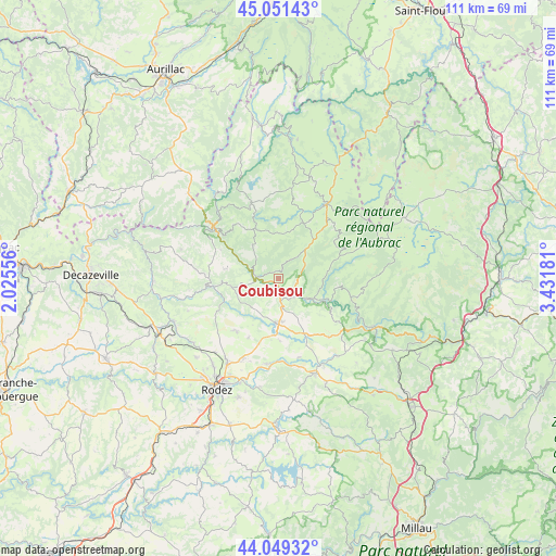
Coubisou GPS coordinates[2]
44° 33' 9.108" North, 2° 43' 43.284" East
| Map corner | latitude | longitude |
|---|---|---|
| Upper-left | 45.05143°, | 2.02556° |
| Center: | 44.55253°, | 2.72869° |
| Lower-right: | 44.04932°, | 3.43181° |
| Map W x H: | 111.4×111.4 km | = 69.2×69.2mi |
| max Lat: | 51.07786° ⇑83.2% North |
| Coubisou: | 44.55253° |
| min Lat: | ⇓16.8% South 41.3874° |
| min Long | Coubisou | max Long |
| -5.08615° | 2.72869° | 9.52242° |
| W 53.9%⇐ | ⇒46.1% E |
Elevation
Elevation of Coubisou is 422 m = 1385 ft, and this is 228.3 m = 749 ft above average elevation for this country.
| Max E: |
2333 m = 7654 ft | 10.2% |
| Coubisou | 422 m 1385 ft | |
| Avg. | 193.7 m = 635 ft | |
Min E: |
-1 m = -3 ft | 89.8% |
See also: France elevation on elevation.city.
Geographical zone
Coubisou is located in North temperate zone (between Tropic of Cancer and the Arctic Circle). Distance of this Northern Tropic circle is 2347.9 km =1458.9 mi to South.| Distance of | km | miles | from Coubisou |
|---|---|---|---|
| North Pole | 5053.3 | 3140 | to North |
| Arctic Circle | 2447.4 | 1520.7 | to North |
| Tropic Cancer | 2347.9 | 1458.9 | to South |
| Equator | 4953.8 | 3078.1 | to South |


Nearby cities:
15 places around Coubisou: (largest is in red/bold)
• Bertholène
18 km =11.2 mi,  166°
166°
• Bozouls
9.1 km =5.7 mi,  182°
182°
• Castelnau-de-Mandailles
12.5 km =7.8 mi,  96°
96°
• Entraygues-sur-Truyère
16.5 km =10.3 mi,  309°
309°
• Espalion
4.3 km =2.7 mi,  141°
141°
• Estaing
4.6 km =2.9 mi,  274°
274°
• La Loubière
20.7 km =12.9 mi,  193°
193°
• Laguiole
17.4 km =10.8 mi,  32°
32°
• Laissac
20.5 km =12.7 mi,  158°
158°
• Le Nayrac
8.5 km =5.3 mi,  323°
323°
• Montpeyroux
12.5 km =7.8 mi,  37°
37°
• Rodelle
10.8 km =6.7 mi,  230°
230°
• Saint-Amans-des-Cots
15.8 km =9.8 mi,  340°
340°
• Sébazac-Concourès
19.2 km =11.9 mi,  211°
211°
• Sénergues
20.2 km =12.6 mi,  286°
286°
Sources, notices
• [Note1] Compared only with cities in France existing in our database
• [Src1] Map data: © OpenStreetMap contributors (CC-BY-SA)
• [Src2] Other city data from geonames.org with taken over terms of usage.
• [Src3] Geographical zone / Annual Mean Temperature by Robert A. Rohde @ Wikipedia
