Béganne geodata
Béganne (Brittany) is a populated place; located in France in Europe/Paris (GMT+2) time zone. With population of 1,407 people, there are 6578 cities with bigger population in this country. Compared to other cities in France, 52.6% of cities are located further ↓South; 95.6% of cities are located further →East and 78.2% of cities have higher elevation than Béganne. Note1
Administrative division(s):
- Level 1: Brittany
- Level 2: Morbihan
- Level 3: Arrondissement de Vannes
- Level 4: Béganne


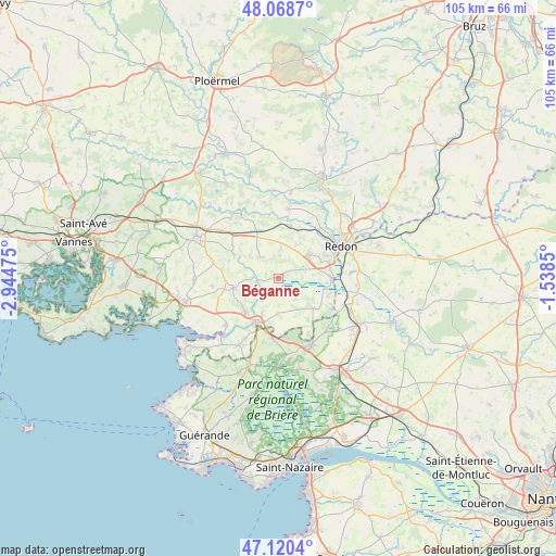
Béganne GPS coordinates[2]
47° 35' 48.12" North, 2° 14' 29.832" West
| Map corner | latitude | longitude |
|---|---|---|
| Upper-left | 48.0687°, | -2.94475° |
| Center: | 47.5967°, | -2.24162° |
| Lower-right: | 47.1204°, | -1.5385° |
| Map W x H: | 105.4×105.4 km | = 65.5×65.5mi |
| max Lat: | 51.07786° ⇑47.4% North |
| Béganne: | 47.5967° |
| min Lat: | ⇓52.6% South 41.3874° |
| min Long | Béganne | max Long |
| -5.08615° | -2.24162° | 9.52242° |
| W 4.4%⇐ | ⇒95.6% E |
Elevation
Elevation of Béganne is 59 m = 194 ft, and this is 134.7 m = 442 ft below average elevation for this country.
| Max E: |
2333 m = 7654 ft | 78.2% |
| Avg. | 193.7 m = 635 ft | |
| Béganne | 59 m = 194 ft | |
Min E: |
-1 m = -3 ft | 21.8% |
See also: France elevation on elevation.city.
Geographical zone
Béganne is located in North temperate zone (between Tropic of Cancer and the Arctic Circle). Distance of this North polar circle is 2108.9 km =1310.4 mi to North.| Distance of | km | miles | from Béganne |
|---|---|---|---|
| North Pole | 4714.8 | 2929.6 | to North |
| Arctic Circle | 2108.9 | 1310.4 | to North |
| Tropic Cancer | 2686.3 | 1669.2 | to South |
| Equator | 5292.3 | 3288.5 | to South |


Nearby cities:
15 places around Béganne: (largest is in red/bold)
• Allaire
7.4 km =4.6 mi,  52°
52°
• Caden
5.1 km =3.2 mi,  318°
318°
• La Roche-Bernard
9.8 km =6.1 mi,  207°
207°
• Le Guerno
12.5 km =7.8 mi,  263°
263°
• Limerzel
9.5 km =5.9 mi,  297°
297°
• Malansac
9.8 km =6.1 mi,  335°
335°
• Marzan
8.8 km =5.5 mi,  225°
225°
• Nivillac
7.7 km =4.8 mi,  203°
203°
• Péaule
8.8 km =5.5 mi, 257°
• Rieux
10 km =6.2 mi,  89°
89°
• Saint-Dolay
8.7 km =5.4 mi,  131°
131°
• Saint-Jacut-les-Pins
10.1 km =6.3 mi,  11°
11°
• Saint-Jean-la-Poterie
9.8 km =6.1 mi,  63°
63°
• Saint-Perreux
12.9 km =8 mi, 51°
• Théhillac
9.9 km =6.2 mi,  109°
109°
Sources, notices
• [Note1] Compared only with cities in France existing in our database
• [Src1] Map data: © OpenStreetMap contributors (CC-BY-SA)
• [Src2] Other city data from geonames.org with taken over terms of usage.
• [Src3] Geographical zone / Annual Mean Temperature by Robert A. Rohde @ Wikipedia
