Saint-Christol geodata
Saint-Christol (Provence-Alpes-Côte d'Azur) is a populated place; located in France in Europe/Paris (GMT+2) time zone. With population of 769 people, there are 10958 cities with bigger population in this country. Compared to other cities in France, 86.9% of cities are located further ↑North; 82.8% of cities are located further ←West and 98.1% of cities have lower elevation than Saint-Christol. Note1
Administrative division(s):
- Level 1: Provence-Alpes-Côte d'Azur
- Level 2: Département du Vaucluse
- Level 3: Arrondissement de Carpentras
- Level 4: Saint-Christol


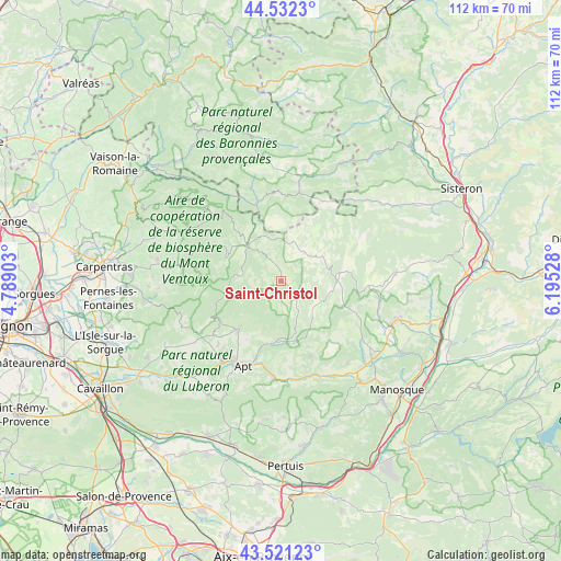
Saint-Christol GPS coordinates[2]
44° 1' 44.112" North, 5° 29' 31.74" East
| Map corner | latitude | longitude |
|---|---|---|
| Upper-left | 44.5323°, | 4.78903° |
| Center: | 44.02892°, | 5.49215° |
| Lower-right: | 43.52123°, | 6.19528° |
| Map W x H: | 112.4×112.4 km | = 69.8×69.8mi |
| max Lat: | 51.07786° ⇑86.9% North |
| Saint-Christol: | 44.02892° |
| min Lat: | ⇓13.1% South 41.3874° |
| min Long | Saint-Christol | max Long |
| -5.08615° | 5.49215° | 9.52242° |
| W 82.8%⇐ | ⇒17.2% E |
Elevation
Elevation of Saint-Christol is 840 m = 2756 ft, and this is 646.3 m = 2120 ft above average elevation for this country.
| Max E: |
2333 m = 7654 ft | 1.9% |
| Saint-Christol | 840 m 2756 ft | |
| Avg. | 193.7 m = 635 ft | |
Min E: |
-1 m = -3 ft | 98.1% |
See also: France elevation on elevation.city.
Geographical zone
Saint-Christol is located in North temperate zone (between Tropic of Cancer and the Arctic Circle). Distance of this Northern Tropic circle is 2289.6 km =1422.7 mi to South.| Distance of | km | miles | from Saint-Christol |
|---|---|---|---|
| North Pole | 5111.5 | 3176.1 | to North |
| Arctic Circle | 2505.6 | 1556.9 | to North |
| Tropic Cancer | 2289.6 | 1422.7 | to South |
| Equator | 4895.6 | 3042 | to South |


Nearby cities:
15 places around Saint-Christol: (largest is in red/bold)
• Apt
18.6 km =11.6 mi,  204°
204°
• Banon
10.9 km =6.8 mi,  84°
84°
• Céreste
20.7 km =12.9 mi,  158°
158°
• Gargas
17.7 km =11 mi,  217°
217°
• Revest-du-Bion
7.5 km =4.7 mi,  36°
36°
• Roussillon
21.3 km =13.2 mi,  228°
228°
• Rustrel
11.6 km =7.2 mi,  182°
182°
• Saignon
19.1 km =11.9 mi, 195°
• Saint-Martin-de-Castillon
18.9 km =11.7 mi, 175°
• Saint-Saturnin-lès-Apt
13.7 km =8.5 mi, 219°
• Sault
9.5 km =5.9 mi,  315°
315°
• Simiane-la-Rotonde
7.8 km =4.8 mi,  133°
133°
• Viens
16 km =9.9 mi, 158°
• Villars
13.6 km =8.5 mi,  210°
210°
• Villes-sur-Auzon
20.8 km =12.9 mi,  278°
278°
Sources, notices
• [Note1] Compared only with cities in France existing in our database
• [Src1] Map data: © OpenStreetMap contributors (CC-BY-SA)
• [Src2] Other city data from geonames.org with taken over terms of usage.
• [Src3] Geographical zone / Annual Mean Temperature by Robert A. Rohde @ Wikipedia
