Sault geodata
Sault (Provence-Alpes-Côte d'Azur) is a populated place; located in France in Europe/Paris (GMT+2) time zone. With population of 1,254 people, there are 7264 cities with bigger population in this country. Compared to other cities in France, 86.3% of cities are located further ↑North; 82% of cities are located further ←West and 97.1% of cities have lower elevation than Sault. Note1
Administrative division(s):
- Level 1: Provence-Alpes-Côte d'Azur
- Level 2: Département du Vaucluse
- Level 3: Arrondissement de Carpentras
- Level 4: Sault


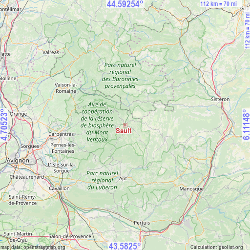
Sault GPS coordinates[2]
44° 5' 22.848" North, 5° 24' 30.096" East
| Map corner | latitude | longitude |
|---|---|---|
| Upper-left | 44.59254°, | 4.70523° |
| Center: | 44.08968°, | 5.40836° |
| Lower-right: | 43.5825°, | 6.11148° |
| Map W x H: | 112.3×112.3 km | = 69.8×69.8mi |
| max Lat: | 51.07786° ⇑86.3% North |
| Sault: | 44.08968° |
| min Lat: | ⇓13.7% South 41.3874° |
| min Long | Sault | max Long |
| -5.08615° | 5.40836° | 9.52242° |
| W 82%⇐ | ⇒18% E |
Elevation
Elevation of Sault is 735 m = 2411 ft, and this is 541.3 m = 1776 ft above average elevation for this country.
| Max E: |
2333 m = 7654 ft | 2.9% |
| Sault | 735 m 2411 ft | |
| Avg. | 193.7 m = 635 ft | |
Min E: |
-1 m = -3 ft | 97.1% |
See also: France elevation on elevation.city.
Geographical zone
Sault is located in North temperate zone (between Tropic of Cancer and the Arctic Circle). Distance of this Northern Tropic circle is 2296.4 km =1426.9 mi to South.| Distance of | km | miles | from Sault |
|---|---|---|---|
| North Pole | 5104.7 | 3171.9 | to North |
| Arctic Circle | 2498.9 | 1552.7 | to North |
| Tropic Cancer | 2296.4 | 1426.9 | to South |
| Equator | 4902.3 | 3046.1 | to South |


Nearby cities:
15 places around Sault: (largest is in red/bold)
• Banon
18.5 km =11.5 mi,  108°
108°
• Bédoin
18.6 km =11.6 mi,  281°
281°
• Gargas
21.3 km =13.2 mi,  190°
190°
• Malemort-du-Comtat
21.3 km =13.2 mi,  248°
248°
• Mazan
22.8 km =14.2 mi,  260°
260°
• Mormoiron
18.2 km =11.3 mi, 262°
• Revest-du-Bion
11.2 km =7 mi,  93°
93°
• Roussillon
22.8 km =14.2 mi,  203°
203°
• Rustrel
19.4 km =12.1 mi,  161°
161°
• Saint-Christol
9.5 km =5.9 mi,  135°
135°
• Saint-Saturnin-lès-Apt
17.5 km =10.9 mi, 186°
• Simiane-la-Rotonde
17.3 km =10.7 mi,  134°
134°
• Venasque
23.4 km =14.5 mi,  243°
243°
• Villars
18.5 km =11.5 mi,  180°
180°
• Villes-sur-Auzon
14.4 km =8.9 mi, 255°
Sources, notices
• [Note1] Compared only with cities in France existing in our database
• [Src1] Map data: © OpenStreetMap contributors (CC-BY-SA)
• [Src2] Other city data from geonames.org with taken over terms of usage.
• [Src3] Geographical zone / Annual Mean Temperature by Robert A. Rohde @ Wikipedia
