Apt geodata
Apt (Provence-Alpes-Côte d'Azur) is a seat of a third-order administrative division; located in France in Europe/Paris (GMT+2) time zone. With population of 11,609 people, there are 826 cities with bigger population in this country. Compared to other cities in France, 88.4% of cities are located further ↑North; 81.8% of cities are located further ←West and 74.2% of cities have lower elevation than Apt. Note1
Administrative division(s):
- Level 1: Provence-Alpes-Côte d'Azur
- Level 2: Département du Vaucluse
- Level 3: Apt
- Level 4: Apt


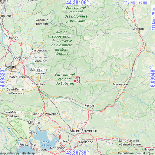
Apt GPS coordinates[2]
43° 52' 34.968" North, 5° 23' 46.86" East
| Map corner | latitude | longitude |
|---|---|---|
| Upper-left | 44.38106°, | 4.69323° |
| Center: | 43.87638°, | 5.39635° |
| Lower-right: | 43.36739°, | 6.09948° |
| Map W x H: | 112.7×112.7 km | = 70×70mi |
| max Lat: | 51.07786° ⇑88.4% North |
| Apt: | 43.87638° |
| min Lat: | ⇓11.6% South 41.3874° |
| min Long | Apt | max Long |
| -5.08615° | 5.39635° | 9.52242° |
| W 81.8%⇐ | ⇒18.2% E |
Elevation
Elevation of Apt is 243 m = 797 ft, and this is 49.3 m = 162 ft above average elevation for this country.
| Max E: |
2333 m = 7654 ft | 25.8% |
| Apt | 243 m 797 ft | |
| Avg. | 193.7 m = 635 ft | |
Min E: |
-1 m = -3 ft | 74.2% |
See also: France elevation on elevation.city.
Geographical zone
Apt is located in North temperate zone (between Tropic of Cancer and the Arctic Circle). Distance of this Northern Tropic circle is 2272.7 km =1412.2 mi to South.| Distance of | km | miles | from Apt |
|---|---|---|---|
| North Pole | 5128.5 | 3186.7 | to North |
| Arctic Circle | 2522.6 | 1567.5 | to North |
| Tropic Cancer | 2272.7 | 1412.2 | to South |
| Equator | 4878.6 | 3031.4 | to South |


Nearby cities:
15 places around Apt: (largest is in red/bold)
• Bonnieux
9.2 km =5.7 mi,  230°
230°
• Cadenet
15.8 km =9.8 mi,  186°
186°
• Cucuron
12 km =7.5 mi,  163°
163°
• Céreste
15.4 km =9.6 mi,  98°
98°
• Gargas
4.2 km =2.6 mi,  312°
312°
• Goult
12.3 km =7.6 mi,  263°
263°
• Lourmarin
12.8 km =8 mi, 192°
• Puyvert
13.7 km =8.5 mi,  198°
198°
• Roussillon
8.8 km =5.5 mi,  289°
289°
• Rustrel
8.9 km =5.5 mi,  53°
53°
• Saignon
3 km =1.9 mi,  119°
119°
• Saint-Martin-de-Castillon
9.4 km =5.8 mi, 101°
• Saint-Saturnin-lès-Apt
6.4 km =4 mi,  350°
350°
• Viens
13.7 km =8.5 mi,  81°
81°
• Villars
5.3 km =3.3 mi,  8°
8°
Sources, notices
• [Note1] Compared only with cities in France existing in our database
• [Src1] Map data: © OpenStreetMap contributors (CC-BY-SA)
• [Src2] Other city data from geonames.org with taken over terms of usage.
• [Src3] Geographical zone / Annual Mean Temperature by Robert A. Rohde @ Wikipedia
