Villars geodata
Villars (Provence-Alpes-Côte d'Azur) is a populated place; located in France in Europe/Paris (GMT+2) time zone. With population of 700 people, there are 11801 cities with bigger population in this country. Compared to other cities in France, 87.8% of cities are located further ↑North; 82% of cities are located further ←West and 83.2% of cities have lower elevation than Villars. Note1
Administrative division(s):
- Level 1: Provence-Alpes-Côte d'Azur
- Level 2: Département du Vaucluse
- Level 3: Apt
- Level 4: Villars


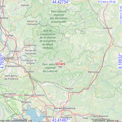
Villars GPS coordinates[2]
43° 55' 23.736" North, 5° 24' 22.284" East
| Map corner | latitude | longitude |
|---|---|---|
| Upper-left | 44.42754°, | 4.70307° |
| Center: | 43.92326°, | 5.40619° |
| Lower-right: | 43.41467°, | 6.10932° |
| Map W x H: | 112.6×112.6 km | = 70×70mi |
| max Lat: | 51.07786° ⇑87.8% North |
| Villars: | 43.92326° |
| min Lat: | ⇓12.2% South 41.3874° |
| min Long | Villars | max Long |
| -5.08615° | 5.40619° | 9.52242° |
| W 82%⇐ | ⇒18% E |
Elevation
Elevation of Villars is 324 m = 1063 ft, and this is 130.3 m = 427 ft above average elevation for this country.
| Max E: |
2333 m = 7654 ft | 16.8% |
| Villars | 324 m 1063 ft | |
| Avg. | 193.7 m = 635 ft | |
Min E: |
-1 m = -3 ft | 83.2% |
See also: France elevation on elevation.city.
Geographical zone
Villars is located in North temperate zone (between Tropic of Cancer and the Arctic Circle). Distance of this Northern Tropic circle is 2277.9 km =1415.4 mi to South.| Distance of | km | miles | from Villars |
|---|---|---|---|
| North Pole | 5123.3 | 3183.5 | to North |
| Arctic Circle | 2517.4 | 1564.2 | to North |
| Tropic Cancer | 2277.9 | 1415.4 | to South |
| Equator | 4883.8 | 3034.7 | to South |


Nearby cities:
15 places around Villars: (largest is in red/bold)
• Apt
5.3 km =3.3 mi,  188°
188°
• Bonnieux
13.6 km =8.5 mi,  215°
215°
• Cucuron
16.9 km =10.5 mi,  171°
171°
• Céreste
16.3 km =10.1 mi,  117°
117°
• Gargas
4.5 km =2.8 mi,  238°
238°
• Gordes
16.6 km =10.3 mi,  266°
266°
• Goult
14.6 km =9.1 mi, 242°
• Roussillon
9.4 km =5.8 mi,  255°
255°
• Rustrel
6.3 km =3.9 mi,  88°
88°
• Saignon
6.9 km =4.3 mi, 165°
• Saint-Christol
13.6 km =8.5 mi,  30°
30°
• Saint-Martin-de-Castillon
11 km =6.8 mi,  129°
129°
• Saint-Saturnin-lès-Apt
2.1 km =1.3 mi,  301°
301°
• Simiane-la-Rotonde
14.1 km =8.8 mi,  62°
62°
• Viens
13.1 km =8.1 mi,  103°
103°
Sources, notices
• [Note1] Compared only with cities in France existing in our database
• [Src1] Map data: © OpenStreetMap contributors (CC-BY-SA)
• [Src2] Other city data from geonames.org with taken over terms of usage.
• [Src3] Geographical zone / Annual Mean Temperature by Robert A. Rohde @ Wikipedia
