Albussac geodata
Albussac (Nouvelle-Aquitaine) is a populated place; located in France in Europe/Paris (GMT+2) time zone. With population of 688 people, there are 11973 cities with bigger population in this country. Compared to other cities in France, 78.1% of cities are located further ↑North; 59% of cities are located further →East and 89.2% of cities have lower elevation than Albussac. Note1
Administrative division(s):
- Level 1: Nouvelle-Aquitaine
- Level 2: Département de la Corrèze
- Level 3: Arrondissement de Tulle
- Level 4: Albussac


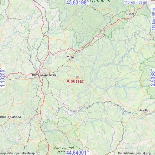
Albussac GPS coordinates[2]
45° 8' 17.34" North, 1° 50' 8.448" East
| Map corner | latitude | longitude |
|---|---|---|
| Upper-left | 45.63198°, | 1.13255° |
| Center: | 45.13815°, | 1.83568° |
| Lower-right: | 44.64001°, | 2.5388° |
| Map W x H: | 110.3×110.3 km | = 68.5×68.5mi |
| max Lat: | 51.07786° ⇑78.1% North |
| Albussac: | 45.13815° |
| min Lat: | ⇓21.9% South 41.3874° |
| min Long | Albussac | max Long |
| -5.08615° | 1.83568° | 9.52242° |
| W 41%⇐ | ⇒59% E |
Elevation
Elevation of Albussac is 410 m = 1345 ft, and this is 216.3 m = 710 ft above average elevation for this country.
| Max E: |
2333 m = 7654 ft | 10.8% |
| Albussac | 410 m 1345 ft | |
| Avg. | 193.7 m = 635 ft | |
Min E: |
-1 m = -3 ft | 89.2% |
See also: France elevation on elevation.city.
Geographical zone
Albussac is located in North temperate zone (between Tropic of Cancer and the Arctic Circle). Distance of this North polar circle is 2382.3 km =1480.3 mi to North.| Distance of | km | miles | from Albussac |
|---|---|---|---|
| North Pole | 4988.2 | 3099.5 | to North |
| Arctic Circle | 2382.3 | 1480.3 | to North |
| Tropic Cancer | 2413 | 1499.4 | to South |
| Equator | 5018.9 | 3118.6 | to South |


Nearby cities:
15 places around Albussac: (largest is in red/bold)
• Argentat
9.4 km =5.8 mi,  121°
121°
• Aubazine
13.4 km =8.3 mi,  287°
287°
• Beynat
9 km =5.6 mi,  260°
260°
• Chameyrat
15.2 km =9.4 mi,  314°
314°
• Chanac-les-Mines
14.1 km =8.8 mi,  354°
354°
• Cornil
13.9 km =8.6 mi, 305°
• Dampniat
16.3 km =10.1 mi,  281°
281°
• Lagarde-Enval
5.9 km =3.7 mi,  337°
337°
• Laguenne
12.3 km =7.6 mi, 339°
• Meyssac
15.7 km =9.8 mi,  234°
234°
• Monceaux-sur-Dordogne
8.4 km =5.2 mi,  137°
137°
• Saint-Chamant
4.9 km =3 mi,  105°
105°
• Sainte-Fortunade
9.2 km =5.7 mi,  326°
326°
• Servières-le-Château
14.9 km =9.3 mi,  93°
93°
• Tulle
15 km =9.3 mi, 340°
Sources, notices
• [Note1] Compared only with cities in France existing in our database
• [Src1] Map data: © OpenStreetMap contributors (CC-BY-SA)
• [Src2] Other city data from geonames.org with taken over terms of usage.
• [Src3] Geographical zone / Annual Mean Temperature by Robert A. Rohde @ Wikipedia
