Monceaux-sur-Dordogne geodata
Monceaux-sur-Dordogne (Nouvelle-Aquitaine) is a populated place; located in France in Europe/Paris (GMT+2) time zone. With population of 680 people, there are 12068 cities with bigger population in this country. Compared to other cities in France, 78.8% of cities are located further ↑North; 58.2% of cities are located further →East and 62.7% of cities have lower elevation than Monceaux-sur-Dordogne. Note1
Administrative division(s):
- Level 1: Nouvelle-Aquitaine
- Level 2: Département de la Corrèze
- Level 3: Arrondissement de Tulle
- Level 4: Monceaux-sur-Dordogne
Current local time in Monceaux-sur-Dordogne:
10:00 AM, SaturdayDifference from your time zone: hours


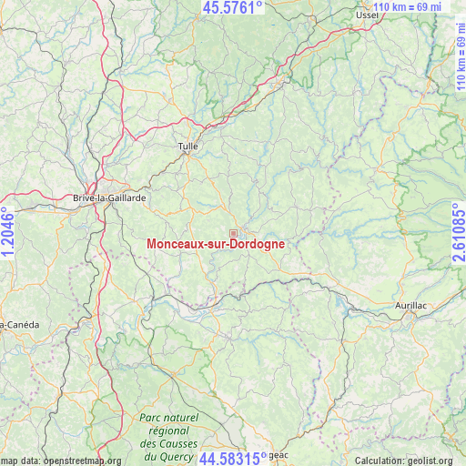
Monceaux-sur-Dordogne GPS coordinates[2]
45° 4' 54.408" North, 1° 54' 27.792" East
| Map corner | latitude | longitude |
|---|---|---|
| Upper-left | 45.5761°, | 1.2046° |
| Center: | 45.08178°, | 1.90772° |
| Lower-right: | 44.58315°, | 2.61085° |
| Map W x H: | 110.4×110.4 km | = 68.6×68.6mi |
| max Lat: | 51.07786° ⇑78.8% North |
| Monceaux-sur-Dordogne: | 45.08178° |
| min Lat: | ⇓21.2% South 41.3874° |
| min Long | Monceaux-sur-Do | max Long |
| -5.08615° | 1.90772° | 9.52242° |
| W 41.8%⇐ | ⇒58.2% E |
Elevation
Elevation of Monceaux-sur-Dordogne is 183 m = 600 ft, and this is 10.7 m = 35 ft below average elevation for this country.
| Max E: |
2333 m = 7654 ft | 37.3% |
| Avg. | 193.7 m = 635 ft | |
| Monceaux-sur-Dordogne | 183 m = 600 ft | |
Min E: |
-1 m = -3 ft | 62.7% |
See also: France elevation on elevation.city.
Geographical zone
Monceaux-sur-Dordogne is located in North temperate zone (between Tropic of Cancer and the Arctic Circle). Distance of this North polar circle is 2388.6 km =1484.2 mi to North.| Distance of | km | miles | from Monceaux-sur-Dordogne |
|---|---|---|---|
| North Pole | 4994.4 | 3103.4 | to North |
| Arctic Circle | 2388.6 | 1484.2 | to North |
| Tropic Cancer | 2406.7 | 1495.5 | to South |
| Equator | 5012.6 | 3114.7 | to South |


Nearby cities:
15 places around Monceaux-sur-Dordogne: (largest is in red/bold)
• Albussac
8.4 km =5.2 mi,  317°
317°
• Altillac
12.5 km =7.8 mi,  201°
201°
• Argentat
2.7 km =1.7 mi,  61°
61°
• Beaulieu-sur-Dordogne
12.7 km =7.9 mi,  205°
205°
• Beynat
15.2 km =9.4 mi,  288°
288°
• Biars-sur-Cère
17.8 km =11.1 mi,  193°
193°
• Bretenoux
19.3 km =12 mi, 195°
• Lagarde-Enval
14.1 km =8.8 mi,  326°
326°
• Meyssac
18.6 km =11.6 mi,  260°
260°
• Puybrun
20.4 km =12.7 mi, 207°
• Saint-Chamant
5 km =3.1 mi,  349°
349°
• Saint-Julien-aux-Bois
18.9 km =11.7 mi,  73°
73°
• Saint-Privat
16.3 km =10.1 mi, 67°
• Sainte-Fortunade
17.6 km =10.9 mi, 322°
• Servières-le-Château
10.7 km =6.6 mi, 59°
Sources, notices
• [Note1] Compared only with cities in France existing in our database
• [Src1] Map data: © OpenStreetMap contributors (CC-BY-SA)
• [Src2] Other city data from geonames.org with taken over terms of usage.
• [Src3] Geographical zone / Annual Mean Temperature by Robert A. Rohde @ Wikipedia
