Bourret geodata
Bourret (Occitanie) is a populated place; located in France in Europe/Paris (GMT+2) time zone. With population of 593 people, there are 13441 cities with bigger population in this country. Compared to other cities in France, 87.6% of cities are located further ↑North; 67.1% of cities are located further →East and 64.9% of cities have higher elevation than Bourret. Note1
Administrative division(s):
- Level 1: Occitanie
- Level 2: Département du Tarn-et-Garonne
- Level 3: Arrondissement de Montauban
- Level 4: Bourret


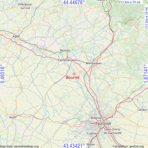
Bourret GPS coordinates[2]
43° 56' 33.504" North, 1° 10' 5.808" East
| Map corner | latitude | longitude |
|---|---|---|
| Upper-left | 44.44676°, | 0.46516° |
| Center: | 43.94264°, | 1.16828° |
| Lower-right: | 43.43421°, | 1.87141° |
| Map W x H: | 112.6×112.6 km | = 70×70mi |
| max Lat: | 51.07786° ⇑87.6% North |
| Bourret: | 43.94264° |
| min Lat: | ⇓12.4% South 41.3874° |
| min Long | Bourret | max Long |
| -5.08615° | 1.16828° | 9.52242° |
| W 32.9%⇐ | ⇒67.1% E |
Elevation
Elevation of Bourret is 90 m = 295 ft, and this is 103.7 m = 340 ft below average elevation for this country.
| Max E: |
2333 m = 7654 ft | 64.9% |
| Avg. | 193.7 m = 635 ft | |
| Bourret | 90 m = 295 ft | |
Min E: |
-1 m = -3 ft | 35.1% |
See also: France elevation on elevation.city.
Geographical zone
Bourret is located in North temperate zone (between Tropic of Cancer and the Arctic Circle). Distance of this Northern Tropic circle is 2280 km =1416.7 mi to South.| Distance of | km | miles | from Bourret |
|---|---|---|---|
| North Pole | 5121.1 | 3182.1 | to North |
| Arctic Circle | 2515.2 | 1562.9 | to North |
| Tropic Cancer | 2280 | 1416.7 | to South |
| Equator | 4886 | 3036 | to South |


Nearby cities:
15 places around Bourret: (largest is in red/bold)
• Bessens
9.9 km =6.2 mi,  136°
136°
• Castelsarrasin
11.9 km =7.4 mi,  335°
335°
• Dieupentale
12.1 km =7.5 mi, 137°
• Escatalens
4.9 km =3 mi,  19°
19°
• Finhan
5.3 km =3.3 mi,  127°
127°
• Garganvillar
9 km =5.6 mi,  296°
296°
• Lacourt-Saint-Pierre
9.1 km =5.7 mi,  58°
58°
• Larrazet
6.9 km =4.3 mi,  259°
259°
• Mas-Grenier
6.1 km =3.8 mi,  158°
158°
• Montbartier
9.1 km =5.7 mi,  110°
110°
• Montech
5.4 km =3.4 mi,  71°
71°
• Saint-Porquier
6.8 km =4.2 mi,  7°
7°
• Saint-Sardos
5.5 km =3.4 mi,  210°
210°
• Sérignac
12 km =7.5 mi, 259°
• Verdun-sur-Garonne
11.1 km =6.9 mi,  151°
151°
Sources, notices
• [Note1] Compared only with cities in France existing in our database
• [Src1] Map data: © OpenStreetMap contributors (CC-BY-SA)
• [Src2] Other city data from geonames.org with taken over terms of usage.
• [Src3] Geographical zone / Annual Mean Temperature by Robert A. Rohde @ Wikipedia
