Tsqaltubo geodata
Tsqaltubo (Imereti) is a populated place; located in Georgia in Asia/Tbilisi (GMT+4) time zone. With population of 16,736 people, there are 20 cities with bigger population in this country. Compared to other cities in Georgia, 71.8% of cities are located further ↓South; 61.5% of cities are located further →East and 70.1% of cities have higher elevation than Tsqaltubo. Note1


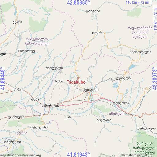
Tsqaltubo GPS coordinates[2]
42° 20' 28.644" North, 42° 35' 51.36" East
| Map corner | latitude | longitude |
|---|---|---|
| Upper-left | 42.85885°, | 41.89448° |
| Center: | 42.34129°, | 42.5976° |
| Lower-right: | 41.81943°, | 43.30073° |
| Map W x H: | 115.6×115.6 km | = 71.8×71.8mi |
| max Lat: | 43.38111° ⇑28.2% North |
| Tsqaltubo: | 42.34129° |
| min Lat: | ⇓71.8% South 41.21725° |
| min Long | Tsqaltubo | max Long |
| 40.07944° | 42.5976° | 46.27667° |
| W 38.5%⇐ | ⇒61.5% E |
Elevation
Elevation of Tsqaltubo is 142 m = 466 ft, and this is 436.8 m = 1433 ft below average elevation for this country.
| Max E: |
2223 m = 7293 ft | 70.1% |
| Avg. | 578.8 m = 1899 ft | |
| Tsqaltubo | 142 m = 466 ft | |
Min E: |
1 m = 3 ft | 29.9% |
See also: Georgia elevation on elevation.city.
Geographical zone
Tsqaltubo is located in North temperate zone (between Tropic of Cancer and the Arctic Circle). Distance of this Northern Tropic circle is 2102 km =1306.1 mi to South.| Distance of | km | miles | from Tsqaltubo |
|---|---|---|---|
| North Pole | 5299.2 | 3292.8 | to North |
| Arctic Circle | 2693.3 | 1673.5 | to North |
| Tropic Cancer | 2102 | 1306.1 | to South |
| Equator | 4707.9 | 2925.4 | to South |


Nearby cities:
15 places around Tsqaltubo: (largest is in red/bold)
• Abasha
34.3 km =21.3 mi,  244°
244°
• Ambrolauri
50.5 km =31.4 mi,  66°
66°
• Gori
50.6 km =31.4 mi, 67°
• Kats’khi
50.6 km =31.4 mi,  96°
96°
• Khoni
14.7 km =9.1 mi,  261°
261°
• Kutaisi
11.4 km =7.1 mi,  135°
135°
• Kveda Chkhorots’q’u
44 km =27.3 mi,  290°
290°
• K’ulashi
25.9 km =16.1 mi,  233°
233°
• Mart’vili
19.7 km =12.2 mi, 294°
• Samtredia
30 km =18.6 mi, 226°
• Senak’i
44.3 km =27.5 mi, 259°
• Shorapani
49 km =30.4 mi,  124°
124°
• Tqibuli
33 km =20.5 mi,  88°
88°
• Vani
29.4 km =18.3 mi,  192°
192°
• Zestap’oni
45.4 km =28.2 mi, 124°
Sources, notices
• [Note1] Compared only with cities in Georgia existing in our database
• [Src1] Map data: © OpenStreetMap contributors (CC-BY-SA)
• [Src2] Other city data from geonames.org with taken over terms of usage.
• [Src3] Geographical zone / Annual Mean Temperature by Robert A. Rohde @ Wikipedia
