Sach’khere geodata
Sach’khere (Imereti) is a populated place; located in Georgia in Asia/Tbilisi (GMT+4) time zone. With population of 6,140 people, there are 50 cities with bigger population in this country. Compared to other cities in Georgia, 72.6% of cities are located further ↓South; 54.7% of cities are located further ←West and 53% of cities have higher elevation than Sach’khere. Note1


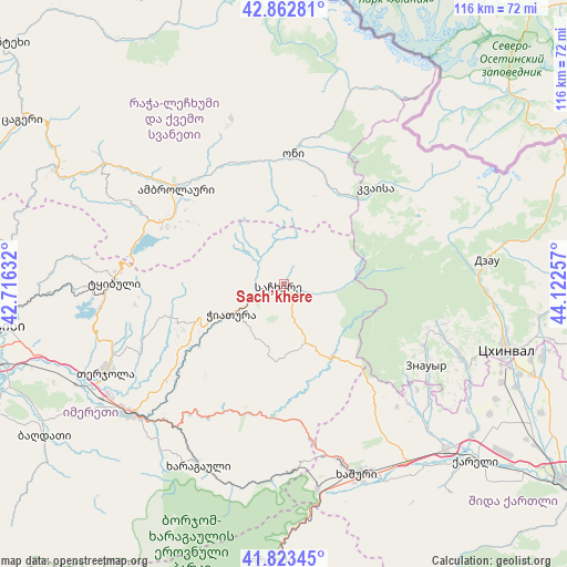
Sach’khere GPS coordinates[2]
42° 20' 43.008" North, 43° 25' 9.984" East
| Map corner | latitude | longitude |
|---|---|---|
| Upper-left | 42.86281°, | 42.71632° |
| Center: | 42.34528°, | 43.41944° |
| Lower-right: | 41.82345°, | 44.12257° |
| Map W x H: | 115.6×115.6 km | = 71.8×71.8mi |
| max Lat: | 43.38111° ⇑27.4% North |
| Sach’khere: | 42.34528° |
| min Lat: | ⇓72.6% South 41.21725° |
| min Long | Sach’khere | max Long |
| 40.07944° | 43.41944° | 46.27667° |
| W 54.7%⇐ | ⇒45.3% E |
Elevation
Elevation of Sach’khere is 484 m = 1588 ft, and this is 94.8 m = 311 ft below average elevation for this country.
| Max E: |
2223 m = 7293 ft | 53% |
| Avg. | 578.8 m = 1899 ft | |
| Sach’khere | 484 m = 1588 ft | |
Min E: |
1 m = 3 ft | 47% |
See also: Georgia elevation on elevation.city.
Geographical zone
Sach’khere is located in North temperate zone (between Tropic of Cancer and the Arctic Circle). Distance of this Northern Tropic circle is 2102.4 km =1306.4 mi to South.| Distance of | km | miles | from Sach’khere |
|---|---|---|---|
| North Pole | 5298.7 | 3292.5 | to North |
| Arctic Circle | 2692.8 | 1673.2 | to North |
| Tropic Cancer | 2102.4 | 1306.4 | to South |
| Equator | 4708.4 | 2925.7 | to South |


Nearby cities:
15 places around Sach’khere: (largest is in red/bold)
• Ambrolauri
28.8 km =17.9 mi,  312°
312°
• Chiat’ura
11.2 km =7 mi,  242°
242°
• Gori
28.2 km =17.5 mi, 312°
• Java
42.9 km =26.7 mi,  81°
81°
• Kats’khi
18.3 km =11.4 mi,  251°
251°
• Kharagauli
40.4 km =25.1 mi,  206°
206°
• Khashuri
41.8 km =26 mi,  159°
159°
• Khet’agurovi
41.8 km =26 mi,  111°
111°
• Oni
26.1 km =16.2 mi,  4°
4°
• Shorapani
39.5 km =24.5 mi,  223°
223°
• Surami
37.4 km =23.2 mi, 162°
• Tbeti
42.6 km =26.5 mi, 107°
• Tqibuli
34.6 km =21.5 mi,  271°
271°
• Zestap’oni
40 km =24.9 mi,  229°
229°
• Znaur
33.6 km =20.9 mi,  119°
119°
Sources, notices
• [Note1] Compared only with cities in Georgia existing in our database
• [Src1] Map data: © OpenStreetMap contributors (CC-BY-SA)
• [Src2] Other city data from geonames.org with taken over terms of usage.
• [Src3] Geographical zone / Annual Mean Temperature by Robert A. Rohde @ Wikipedia
