Senak’i geodata
Senak’i (Samegrelo and Zemo Svaneti) is a populated place; located in Georgia in Asia/Tbilisi (GMT+4) time zone. With population of 27,752 people, there are 11 cities with bigger population in this country. Compared to other cities in Georgia, 67.5% of cities are located further ↓South; 72.6% of cities are located further →East and 80.3% of cities have higher elevation than Senak’i. Note1


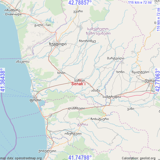
Senak’i GPS coordinates[2]
42° 16' 13.512" North, 42° 4' 3" East
| Map corner | latitude | longitude |
|---|---|---|
| Upper-left | 42.78857°, | 41.36438° |
| Center: | 42.27042°, | 42.0675° |
| Lower-right: | 41.74798°, | 42.77063° |
| Map W x H: | 115.7×115.7 km | = 71.9×71.9mi |
| max Lat: | 43.38111° ⇑32.5% North |
| Senak’i: | 42.27042° |
| min Lat: | ⇓67.5% South 41.21725° |
| min Long | Senak’i | max Long |
| 40.07944° | 42.0675° | 46.27667° |
| W 27.4%⇐ | ⇒72.6% E |
Elevation
Elevation of Senak’i is 36 m = 118 ft, and this is 542.8 m = 1781 ft below average elevation for this country.
| Max E: |
2223 m = 7293 ft | 80.3% |
| Avg. | 578.8 m = 1899 ft | |
| Senak’i | 36 m = 118 ft | |
Min E: |
1 m = 3 ft | 19.7% |
See also: Georgia elevation on elevation.city.
Geographical zone
Senak’i is located in North temperate zone (between Tropic of Cancer and the Arctic Circle). Distance of this Northern Tropic circle is 2094.1 km =1301.2 mi to South.| Distance of | km | miles | from Senak’i |
|---|---|---|---|
| North Pole | 5307 | 3297.6 | to North |
| Arctic Circle | 2701.1 | 1678.4 | to North |
| Tropic Cancer | 2094.1 | 1301.2 | to South |
| Equator | 4700 | 2920.4 | to South |


Nearby cities:
15 places around Senak’i: (largest is in red/bold)
• Abasha
14.3 km =8.9 mi,  118°
118°
• Khobi
14.8 km =9.2 mi,  289°
289°
• Khoni
29.6 km =18.4 mi,  78°
78°
• Kveda Chkhorots’q’u
23.5 km =14.6 mi,  5°
5°
• K’ulashi
23.8 km =14.8 mi,  108°
108°
• Lanchkhuti
20.2 km =12.6 mi,  188°
188°
• Mart’vili
30.2 km =18.8 mi,  58°
58°
• Naruja
41.5 km =25.8 mi, 193°
• Orsant’ia
39.1 km =24.3 mi,  304°
304°
• Ozurgeti
38.8 km =24.1 mi, 187°
• P’ot’i
35.4 km =22 mi,  247°
247°
• Samtredia
25.6 km =15.9 mi, 120°
• Tsalenjikha
37.1 km =23.1 mi,  0°
0°
• Urek’i
38.7 km =24 mi,  217°
217°
• Zugdidi
31 km =19.3 mi,  328°
328°
Sources, notices
• [Note1] Compared only with cities in Georgia existing in our database
• [Src1] Map data: © OpenStreetMap contributors (CC-BY-SA)
• [Src2] Other city data from geonames.org with taken over terms of usage.
• [Src3] Geographical zone / Annual Mean Temperature by Robert A. Rohde @ Wikipedia
