Sioni geodata
Sioni (Mtskheta-Mtianeti) is a populated place; located in Georgia in Asia/Tbilisi (GMT+4) time zone. With population of 777 people, there are 100 cities with bigger population in this country. Compared to other cities in Georgia, 83.8% of cities are located further ↓South; 78.6% of cities are located further ←West and 97.4% of cities have lower elevation than Sioni. Note1


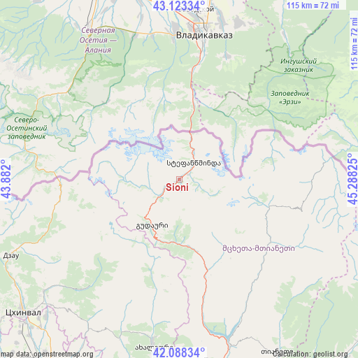
Sioni GPS coordinates[2]
42° 36' 28.764" North, 44° 35' 6.432" East
| Map corner | latitude | longitude |
|---|---|---|
| Upper-left | 43.12334°, | 43.882° |
| Center: | 42.60799°, | 44.58512° |
| Lower-right: | 42.08834°, | 45.28825° |
| Map W x H: | 115.1×115.1 km | = 71.5×71.5mi |
| max Lat: | 43.38111° ⇑16.2% North |
| Sioni: | 42.60799° |
| min Lat: | ⇓83.8% South 41.21725° |
| min Long | Sioni | max Long |
| 40.07944° | 44.58512° | 46.27667° |
| W 78.6%⇐ | ⇒21.4% E |
Elevation
Elevation of Sioni is 1861 m = 6106 ft, and this is 1282.2 m = 4207 ft above average elevation for this country.
| Max E: |
2223 m = 7293 ft | 2.6% |
| Sioni | 1861 m 6106 ft | |
| Avg. | 578.8 m = 1899 ft | |
Min E: |
1 m = 3 ft | 97.4% |
See also: Georgia elevation on elevation.city.
Geographical zone
Sioni is located in North temperate zone (between Tropic of Cancer and the Arctic Circle). Distance of this Northern Tropic circle is 2131.6 km =1324.5 mi to South.| Distance of | km | miles | from Sioni |
|---|---|---|---|
| North Pole | 5269.5 | 3274.3 | to North |
| Arctic Circle | 2663.6 | 1655.1 | to North |
| Tropic Cancer | 2131.6 | 1324.5 | to South |
| Equator | 4737.6 | 2943.8 | to South |


Nearby cities:
15 places around Sioni: (largest is in red/bold)
• Akhalgori
54.2 km =33.7 mi,  188°
188°
• Gori
79.4 km =49.3 mi,  209°
209°
• Gudauri
17 km =10.6 mi, 211°
• Java
58 km =36 mi,  246°
246°
• Kaspi
77 km =47.8 mi, 189°
• Khet’agurovi
72.2 km =44.9 mi,  231°
231°
• P’asanauri
29.9 km =18.6 mi,  163°
163°
• Samt’avisi
68.3 km =42.4 mi, 192°
• Step’antsminda
7.2 km =4.5 mi,  41°
41°
• Tbeti
69.4 km =43.1 mi, 232°
• Ts’khinvali
66 km =41 mi, 230°
• T’ianet’i
63.7 km =39.6 mi,  150°
150°
• Uplistsikhe
79.1 km =49.2 mi, 205°
• Zhinvali
55.1 km =34.2 mi, 163°
• Znaur
81 km =50.3 mi,  235°
235°
Sources, notices
• [Note1] Compared only with cities in Georgia existing in our database
• [Src1] Map data: © OpenStreetMap contributors (CC-BY-SA)
• [Src2] Other city data from geonames.org with taken over terms of usage.
• [Src3] Geographical zone / Annual Mean Temperature by Robert A. Rohde @ Wikipedia
