Mest’ia geodata
Mest’ia (Samegrelo and Zemo Svaneti) is a populated place; located in Georgia in Asia/Tbilisi (GMT+4) time zone. With population of 3,187 people, there are 69 cities with bigger population in this country. Compared to other cities in Georgia, 94% of cities are located further ↓South; 58.1% of cities are located further →East and 92.3% of cities have lower elevation than Mest’ia. Note1


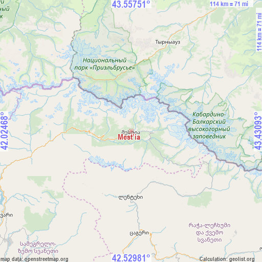
Mest’ia GPS coordinates[2]
43° 2' 44.916" North, 42° 43' 40.08" East
| Map corner | latitude | longitude |
|---|---|---|
| Upper-left | 43.55751°, | 42.02468° |
| Center: | 43.04581°, | 42.7278° |
| Lower-right: | 42.52981°, | 43.43093° |
| Map W x H: | 114.3×114.3 km | = 71×71mi |
| max Lat: | 43.38111° ⇑6% North |
| Mest’ia: | 43.04581° |
| min Lat: | ⇓94% South 41.21725° |
| min Long | Mest’ia | max Long |
| 40.07944° | 42.7278° | 46.27667° |
| W 41.9%⇐ | ⇒58.1% E |
Elevation
Elevation of Mest’ia is 1412 m = 4633 ft, and this is 833.2 m = 2734 ft above average elevation for this country.
| Max E: |
2223 m = 7293 ft | 7.7% |
| Mest’ia | 1412 m 4633 ft | |
| Avg. | 578.8 m = 1899 ft | |
Min E: |
1 m = 3 ft | 92.3% |
See also: Georgia elevation on elevation.city.
Geographical zone
Mest’ia is located in North temperate zone (between Tropic of Cancer and the Arctic Circle). Distance of this Northern Tropic circle is 2180.3 km =1354.8 mi to South.| Distance of | km | miles | from Mest’ia |
|---|---|---|---|
| North Pole | 5220.8 | 3244.1 | to North |
| Arctic Circle | 2614.9 | 1624.8 | to North |
| Tropic Cancer | 2180.3 | 1354.8 | to South |
| Equator | 4786.2 | 2974 | to South |


Nearby cities:
15 places around Mest’ia: (largest is in red/bold)
• Ambrolauri
68.3 km =42.4 mi,  148°
148°
• Gori
68.9 km =42.8 mi, 148°
• Jvari
66.1 km =41.1 mi,  236°
236°
• Kats’khi
92.5 km =57.5 mi, 154°
• Khoni
84.2 km =52.3 mi,  197°
197°
• Kutaisi
86.5 km =53.7 mi,  181°
181°
• Kveda Chkhorots’q’u
81.2 km =50.5 mi,  219°
219°
• Lent’ekhi
28.6 km =17.8 mi, 180°
• Mart’vili
75.8 km =47.1 mi, 202°
• Oni
78 km =48.5 mi,  131°
131°
• Tqibuli
80.3 km =49.9 mi,  164°
164°
• Tqvarch'eli
88.3 km =54.9 mi,  255°
255°
• Tsalenjikha
72.8 km =45.2 mi,  227°
227°
• Tsqaltubo
79.1 km =49.2 mi,  187°
187°
• Zugdidi
92 km =57.2 mi, 229°
Sources, notices
• [Note1] Compared only with cities in Georgia existing in our database
• [Src1] Map data: © OpenStreetMap contributors (CC-BY-SA)
• [Src2] Other city data from geonames.org with taken over terms of usage.
• [Src3] Geographical zone / Annual Mean Temperature by Robert A. Rohde @ Wikipedia
