Oni geodata
Oni (Racha-Lechkhumi and Kvemo Svaneti) is a seat of a second-order administrative division; located in Georgia in Asia/Tbilisi (GMT+4) time zone. With population of 3,012 people, there are 72 cities with bigger population in this country. Compared to other cities in Georgia, 82.1% of cities are located further ↓South; 55.6% of cities are located further ←West and 74.4% of cities have lower elevation than Oni. Note1


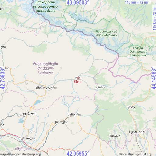
Oni GPS coordinates[2]
42° 34' 45.984" North, 43° 26' 33" East
| Map corner | latitude | longitude |
|---|---|---|
| Upper-left | 43.09503°, | 42.73938° |
| Center: | 42.57944°, | 43.4425° |
| Lower-right: | 42.05955°, | 44.14563° |
| Map W x H: | 115.1×115.1 km | = 71.5×71.5mi |
| max Lat: | 43.38111° ⇑17.9% North |
| Oni: | 42.57944° |
| min Lat: | ⇓82.1% South 41.21725° |
| min Long | Oni | max Long |
| 40.07944° | 43.4425° | 46.27667° |
| W 55.6%⇐ | ⇒44.4% E |
Elevation
Elevation of Oni is 838 m = 2749 ft, and this is 259.2 m = 850 ft above average elevation for this country.
| Max E: |
2223 m = 7293 ft | 25.6% |
| Oni | 838 m 2749 ft | |
| Avg. | 578.8 m = 1899 ft | |
Min E: |
1 m = 3 ft | 74.4% |
See also: Georgia elevation on elevation.city.
Geographical zone
Oni is located in North temperate zone (between Tropic of Cancer and the Arctic Circle). Distance of this Northern Tropic circle is 2128.5 km =1322.6 mi to South.| Distance of | km | miles | from Oni |
|---|---|---|---|
| North Pole | 5272.7 | 3276.3 | to North |
| Arctic Circle | 2666.8 | 1657.1 | to North |
| Tropic Cancer | 2128.5 | 1322.6 | to South |
| Equator | 4734.4 | 2941.8 | to South |


Nearby cities:
15 places around Oni: (largest is in red/bold)
• Ambrolauri
23.9 km =14.9 mi,  254°
254°
• Chiat’ura
33.4 km =20.8 mi,  200°
200°
• Gori
23.6 km =14.7 mi, 252°
• Java
45.2 km =28.1 mi,  116°
116°
• Kats’khi
37.2 km =23.1 mi,  210°
210°
• Khet’agurovi
55.4 km =34.4 mi,  138°
138°
• Lent’ekhi
63.3 km =39.3 mi,  291°
291°
• Sach’khere
26.1 km =16.2 mi,  184°
184°
• Shorapani
61.8 km =38.4 mi, 208°
• Surami
62.4 km =38.8 mi,  171°
171°
• Tbeti
54.8 km =34.1 mi, 135°
• Tqibuli
44.4 km =27.6 mi,  235°
235°
• Ts’khinvali
58.3 km =36.2 mi,  132°
132°
• Zestap’oni
61.3 km =38.1 mi, 211°
• Znaur
50.7 km =31.5 mi,  147°
147°
Sources, notices
• [Note1] Compared only with cities in Georgia existing in our database
• [Src1] Map data: © OpenStreetMap contributors (CC-BY-SA)
• [Src2] Other city data from geonames.org with taken over terms of usage.
• [Src3] Geographical zone / Annual Mean Temperature by Robert A. Rohde @ Wikipedia
