Lent’ekhi geodata
Lent’ekhi (Racha-Lechkhumi and Kvemo Svaneti) is a populated place; located in Georgia in Asia/Tbilisi (GMT+4) time zone. With population of 10,442 people, there are 31 cities with bigger population in this country. Compared to other cities in Georgia, 88% of cities are located further ↓South; 59% of cities are located further →East and 65% of cities have lower elevation than Lent’ekhi. Note1


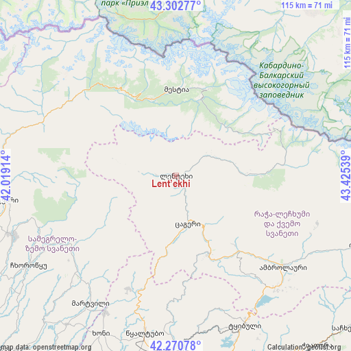
Lent’ekhi GPS coordinates[2]
42° 47' 20.148" North, 42° 43' 20.136" East
| Map corner | latitude | longitude |
|---|---|---|
| Upper-left | 43.30277°, | 42.01914° |
| Center: | 42.78893°, | 42.72226° |
| Lower-right: | 42.27078°, | 43.42539° |
| Map W x H: | 114.7×114.7 km | = 71.3×71.3mi |
| max Lat: | 43.38111° ⇑12% North |
| Lent’ekhi: | 42.78893° |
| min Lat: | ⇓88% South 41.21725° |
| min Long | Lent’ekhi | max Long |
| 40.07944° | 42.72226° | 46.27667° |
| W 41%⇐ | ⇒59% E |
Elevation
Elevation of Lent’ekhi is 738 m = 2421 ft, and this is 159.2 m = 522 ft above average elevation for this country.
| Max E: |
2223 m = 7293 ft | 35% |
| Lent’ekhi | 738 m 2421 ft | |
| Avg. | 578.8 m = 1899 ft | |
Min E: |
1 m = 3 ft | 65% |
See also: Georgia elevation on elevation.city.
Geographical zone
Lent’ekhi is located in North temperate zone (between Tropic of Cancer and the Arctic Circle). Distance of this Northern Tropic circle is 2151.8 km =1337.1 mi to South.| Distance of | km | miles | from Lent’ekhi |
|---|---|---|---|
| North Pole | 5249.4 | 3261.8 | to North |
| Arctic Circle | 2643.5 | 1642.6 | to North |
| Tropic Cancer | 2151.8 | 1337.1 | to South |
| Equator | 4757.7 | 2956.3 | to South |


Nearby cities:
15 places around Lent’ekhi: (largest is in red/bold)
• Ambrolauri
46.7 km =29 mi,  129°
129°
• Chiat’ura
72.2 km =44.9 mi,  139°
139°
• Gori
47.3 km =29.4 mi, 129°
• Jvari
55.3 km =34.4 mi,  261°
261°
• Kats’khi
68.1 km =42.3 mi, 144°
• Khoni
57.4 km =35.7 mi,  205°
205°
• Kutaisi
58 km =36 mi,  182°
182°
• Kveda Chkhorots’q’u
61.6 km =38.3 mi,  236°
236°
• K’ulashi
72.1 km =44.8 mi, 205°
• Mart’vili
50.2 km =31.2 mi, 213°
• Mest’ia
28.6 km =17.8 mi,  0°
0°
• Oni
63.3 km =39.3 mi,  111°
111°
• Tqibuli
53.7 km =33.4 mi,  155°
155°
• Tsalenjikha
57.2 km =35.5 mi,  249°
249°
• Tsqaltubo
50.8 km =31.6 mi,  191°
191°
Sources, notices
• [Note1] Compared only with cities in Georgia existing in our database
• [Src1] Map data: © OpenStreetMap contributors (CC-BY-SA)
• [Src2] Other city data from geonames.org with taken over terms of usage.
• [Src3] Geographical zone / Annual Mean Temperature by Robert A. Rohde @ Wikipedia
