Znaur geodata
Znaur is a populated place; located in Georgia in Asia/Tbilisi (GMT+4) time zone. With population of 755 people, there are 102 cities with bigger population in this country. Compared to other cities in Georgia, 61.5% of cities are located further ↓South; 64.1% of cities are located further ←West and 70.9% of cities have lower elevation than Znaur. Note1


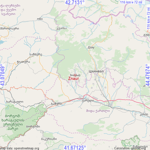
Znaur GPS coordinates[2]
42° 11' 39.552" North, 43° 46' 24.996" East
| Map corner | latitude | longitude |
|---|---|---|
| Upper-left | 42.7131°, | 43.07049° |
| Center: | 42.19432°, | 43.77361° |
| Lower-right: | 41.67125°, | 44.47674° |
| Map W x H: | 115.8×115.8 km | = 72×72mi |
| max Lat: | 43.38111° ⇑38.5% North |
| Znaur: | 42.19432° |
| min Lat: | ⇓61.5% South 41.21725° |
| min Long | Znaur | max Long |
| 40.07944° | 43.77361° | 46.27667° |
| W 64.1%⇐ | ⇒35.9% E |
Elevation
Elevation of Znaur is 783 m = 2569 ft, and this is 204.2 m = 670 ft above average elevation for this country.
| Max E: |
2223 m = 7293 ft | 29.1% |
| Znaur | 783 m 2569 ft | |
| Avg. | 578.8 m = 1899 ft | |
Min E: |
1 m = 3 ft | 70.9% |
See also: Georgia elevation on elevation.city.
Geographical zone
Znaur is located in North temperate zone (between Tropic of Cancer and the Arctic Circle). Distance of this Northern Tropic circle is 2085.6 km =1295.9 mi to South.| Distance of | km | miles | from Znaur |
|---|---|---|---|
| North Pole | 5315.5 | 3302.9 | to North |
| Arctic Circle | 2709.6 | 1683.7 | to North |
| Tropic Cancer | 2085.6 | 1295.9 | to South |
| Equator | 4691.6 | 2915.2 | to South |


Nearby cities:
15 places around Znaur: (largest is in red/bold)
• Agara
17.9 km =11.1 mi,  166°
166°
• Akhaldaba
37.7 km =23.4 mi,  218°
218°
• Borjomi
48.3 km =30 mi, 218°
• Chiat’ura
40.7 km =25.3 mi,  286°
286°
• Gori
36.6 km =22.7 mi,  129°
129°
• Java
26.5 km =16.5 mi,  30°
30°
• Kats’khi
47.7 km =29.6 mi,  283°
283°
• Khashuri
26.5 km =16.5 mi,  212°
212°
• Khet’agurovi
9.9 km =6.2 mi,  80°
80°
• Sach’khere
33.6 km =20.9 mi,  299°
299°
• Surami
26.1 km =16.2 mi, 223°
• Tbeti
12.1 km =7.5 mi,  70°
70°
• Tsaghveri
49.7 km =30.9 mi, 209°
• Ts’khinvali
16.5 km =10.3 mi, 77°
• Uplistsikhe
41.5 km =25.8 mi, 127°
Sources, notices
• [Note1] Compared only with cities in Georgia existing in our database
• [Src1] Map data: © OpenStreetMap contributors (CC-BY-SA)
• [Src2] Other city data from geonames.org with taken over terms of usage.
• [Src3] Geographical zone / Annual Mean Temperature by Robert A. Rohde @ Wikipedia
