Kaparéllion geodata
Kaparéllion (Central Greece) is a populated place; located in Greece in Europe/Athens (GMT+3) time zone. With population of 1,478 people, there are 675 cities with bigger population in this country. Compared to other cities in Greece, 67.3% of cities are located further ↑North; 58.7% of cities are located further ←West and 82.7% of cities have lower elevation than Kaparéllion. Note1


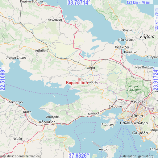
Kaparéllion GPS coordinates[2]
38° 14' 13.092" North, 23° 12' 50.796" East
| Map corner | latitude | longitude |
|---|---|---|
| Upper-left | 38.78714°, | 22.51099° |
| Center: | 38.23697°, | 23.21411° |
| Lower-right: | 37.6826°, | 23.91724° |
| Map W x H: | 122.8×122.8 km | = 76.3×76.3mi |
| max Lat: | 41.72048° ⇑67.3% North |
| Kaparéllion: | 38.23697° |
| min Lat: | ⇓32.7% South 34.8346° |
| min Long | Kaparéllion | max Long |
| 19.40494° | 23.21411° | 29.59361° |
| W 58.7%⇐ | ⇒41.3% E |
Elevation
Elevation of Kaparéllion is 326 m = 1070 ft, and this is 157.1 m = 515 ft above average elevation for this country.
| Max E: |
1439 m = 4721 ft | 17.3% |
| Kaparéllion | 326 m 1070 ft | |
| Avg. | 168.9 m = 554 ft | |
Min E: |
0 m = 0 ft | 82.7% |
See also: Greece elevation on elevation.city.
Geographical zone
Kaparéllion is located in North temperate zone (between Tropic of Cancer and the Arctic Circle). Distance of this Northern Tropic circle is 1645.6 km =1022.5 mi to South.| Distance of | km | miles | from Kaparéllion |
|---|---|---|---|
| North Pole | 5755.5 | 3576.3 | to North |
| Arctic Circle | 3149.6 | 1957.1 | to North |
| Tropic Cancer | 1645.6 | 1022.5 | to South |
| Equator | 4251.6 | 2641.8 | to South |


Nearby cities:
15 places around Kaparéllion: (largest is in red/bold)
• Akraifnía
24.4 km =15.2 mi,  1°
1°
• Alíartos
17.5 km =10.9 mi,  325°
325°
• Asopía
26 km =16.2 mi,  74°
74°
• Domvraína
20.3 km =12.6 mi,  275°
275°
• Eleónas
24.5 km =15.2 mi,  54°
54°
• Erythrés
9.7 km =6 mi,  102°
102°
• Kallithea - Moustafádhes
21.3 km =13.2 mi, 67°
• Kástron
28.9 km =18 mi,  350°
350°
• Kókkinon
26.6 km =16.5 mi, 4°
• Plataiés
5.3 km =3.3 mi,  119°
119°
• Thespiés
9.2 km =5.7 mi,  322°
322°
• Thívai
13.4 km =8.3 mi,  43°
43°
• Vágia
9.5 km =5.9 mi,  340°
340°
• Vília
13.2 km =8.2 mi,  125°
125°
• Árma
26.9 km =16.7 mi,  61°
61°
Sources, notices
• [Note1] Compared only with cities in Greece existing in our database
• [Src1] Map data: © OpenStreetMap contributors (CC-BY-SA)
• [Src2] Other city data from geonames.org with taken over terms of usage.
• [Src3] Geographical zone / Annual Mean Temperature by Robert A. Rohde @ Wikipedia
