Koróni geodata
Koróni (Peloponnese) is a populated place; located in Greece in Europe/Athens (GMT+3) time zone. With population of 1,620 people, there are 616 cities with bigger population in this country. Compared to other cities in Greece, 91.3% of cities are located further ↑North; 73.3% of cities are located further →East and 64.6% of cities have higher elevation than Koróni. Note1
Administrative division(s):
- Level 1: Peloponnese
- Level 2: Nomós Messinías
- Level 3: Dimos Pylos-Nestoras


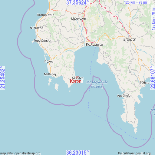
Koróni GPS coordinates[2]
36° 47' 42.936" North, 21° 57' 28.584" East
| Map corner | latitude | longitude |
|---|---|---|
| Upper-left | 37.35624°, | 21.25482° |
| Center: | 36.79526°, | 21.95794° |
| Lower-right: | 36.23015°, | 22.66107° |
| Map W x H: | 125.2×125.2 km | = 77.8×77.8mi |
| max Lat: | 41.72048° ⇑91.3% North |
| Koróni: | 36.79526° |
| min Lat: | ⇓8.7% South 34.8346° |
| min Long | Koróni | max Long |
| 19.40494° | 21.95794° | 29.59361° |
| W 26.7%⇐ | ⇒73.3% E |
Elevation
Elevation of Koróni is 40 m = 131 ft, and this is 128.9 m = 423 ft below average elevation for this country.
| Max E: |
1439 m = 4721 ft | 64.6% |
| Avg. | 168.9 m = 554 ft | |
| Koróni | 40 m = 131 ft | |
Min E: |
0 m = 0 ft | 35.4% |
See also: Greece elevation on elevation.city.
Geographical zone
Koróni is located in North temperate zone (between Tropic of Cancer and the Arctic Circle). Distance of this Northern Tropic circle is 1485.3 km =922.9 mi to South.| Distance of | km | miles | from Koróni |
|---|---|---|---|
| North Pole | 5915.8 | 3675.9 | to North |
| Arctic Circle | 3309.9 | 2056.7 | to North |
| Tropic Cancer | 1485.3 | 922.9 | to South |
| Equator | 4091.2 | 2542.2 | to South |


Nearby cities:
15 places around Koróni: (largest is in red/bold)
• Asprókhoma
29.9 km =18.6 mi,  20°
20°
• Kalamata
30.4 km =18.9 mi,  26°
26°
• Kardamýli
26.6 km =16.5 mi,  67°
67°
• Laíika
32.1 km =19.9 mi, 22°
• Longá
9.4 km =5.8 mi,  330°
330°
• Messíni
28.8 km =17.9 mi,  8°
8°
• Methóni
22.7 km =14.1 mi,  276°
276°
• Mikrománi
32 km =19.9 mi, 11°
• Mikrá Mantíneia
27.4 km =17 mi,  39°
39°
• Paralía Vérgas
29.4 km =18.3 mi, 36°
• Pýlos
26.7 km =16.6 mi,  299°
299°
• Sperchógeia
32.4 km =20.1 mi, 16°
• Stoúpa
27.4 km =17 mi,  78°
78°
• Thouría
33.1 km =20.6 mi, 14°
• Vlachópoulo
30.2 km =18.8 mi, 330°
Sources, notices
• [Note1] Compared only with cities in Greece existing in our database
• [Src1] Map data: © OpenStreetMap contributors (CC-BY-SA)
• [Src2] Other city data from geonames.org with taken over terms of usage.
• [Src3] Geographical zone / Annual Mean Temperature by Robert A. Rohde @ Wikipedia
